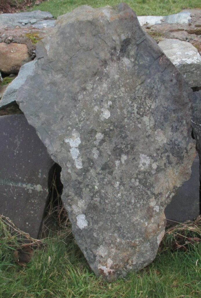
Yr Cymmrodor vol 33 p101, the report of the excavations of the Roman fort at Segontium in the 1920s, comments “In regard to the [discovery of considerable quantities of slate], Dr. Greenly observes: “Perhaps the most interesting circumstance in connection with the materials of Segontium is that the Romans discovered the now celebrated purple slates of the Cambrian system in Carnarvonshire, which have been so extensively quarried in modern times. The slate may be termed a “local” rock, in the sense that it occurs in the district ; but its nearest outcrops are five miles away, from which it is evident that the builders had appreciated its remarkable qualities. They used thick slabs of it for flooring, and thin ones for roofing, slates having been found which had been pierced for fixing on a roof. They do not appear to have obtained the finest and most fissile varieties, all the slates which have been seen at Segontium being slightly, though very slightly, sandy. This was probably because the finest beds tend to weather into smooth slopes, whereas the sandy beds are apt to outcrop in little escarpmental crags, and thus be much more conspicuous. No older record of the use of these slates is known, so that there can be little doubt that the Romans were the first to discover them.” I live adjacent to Dinorwig quarry, and own one such sandy slab.
A Roman milestone was found in a group of buildings in 1798 at SH56456360 GAT2419. The inscription on it cannot now be confidently deciphered. In an area where large boulders for walling are so abundant it is hardly necessary to transport rock even a modest distance, it seems unlikely this milestone would have been transported several miles from the nearest known Roman road. Why not look at the road beside which it was found? – passing through Clwt y Bont and ignoring the village of Deiniolen (formerly Ebenezer) which grew up round the quarry access road built by the Vaynol estate in 1812. Before then this route was the only way of accessing Dinorwig itself.
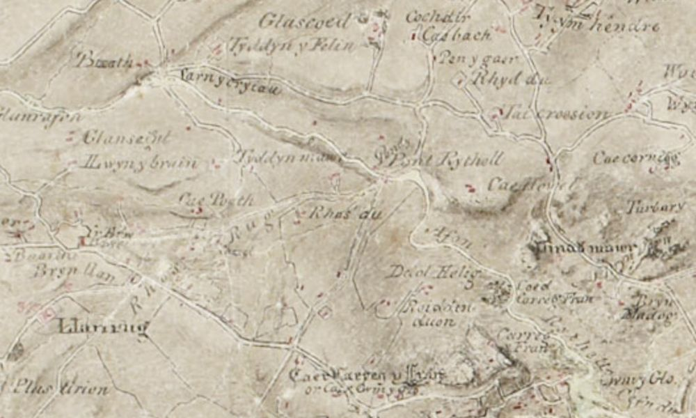
Starting from the vicinity of Canovium – Segontium road at SH531648, there is a lane which goes straight on to Penisarwaun after the more important bus route to Llanrug bears S at SH53326445 and then continues on to Clwt y Bont. It appears on 1818, where it is described in Gothic lettering as “Sarn y cryiau” (? = bedding causeway) This is direct rather than aligned, although E of Penisarwaun it is “warped straight”, and is all but level. After crossing the A4244 (formerly B4547) the road passes the site where the milestone was found, and continues climbing gently until it comes to a steep pitch at SH57176319. After crossing the Dinorwig Tramroad of 1824 at SH57466309, the current main road bears N up hill, minor road goes straight on, and on S side at SH57576304 there is Tan yr Henffordd (“below the old road”), which looks as though it was originally a 2 roomed cottage now much extended. Then again, by Deiniolen Silver Band room, the more used road turns N, and lane goes on and immediately swings through a sharp upstream zigzag over river Caledffrwd SH57836296. The bridge here was rebuilt in 2015 after the old one collapsed in a major flood in 2012. That was constructed of huge slate slabs typical of the early industrial revolution. Prior to this there were slight traces of edge-on paving below the bridge on N side, maybe indicating a ford, but these disappeared in the reconstruction. At SH57956294 the road veers N round a mound of earth, but the S field wall goes straight on, and there is an old opening for a wicket gate in it halfway along the line. All this stretch from the main road, through what is now the village of Clwt y Bont, and including the zigzag, appears on the Llanddeiniolen enclosure award of 1813 (GAS) and 1818. On these maps the track then turns abruptly S at SH57976292, this still exists as a footpath, the road going straight on is not marked but logically must have been there. Bear in mind these maps do not show what were at the time considered paths, not roads. A small stream (now culverted) is crossed at SH58246284, then at SH58526282 it crosses the 1812 quarry road and goes very steeply up the side of a tributary of Caledffrwd, as a lane called Lon Bwlch up to a small windgap at the top. The terraceway is most pronounced at SH58626254, where a retaining wall some 8ft high is beginning to fall in. Another minor road is joined at SH58706231 and then continues S to a T junction with Lon Garret at SH58716195. The modern road then descends slightly to the village of Dinorwig, where it could have gone to Chwarel Fawr and Allt Ddu quarries, now landscaped and the destination of the 1812 cart road. Alternatively there is the very striking feature of Lon Garrett climbing across the mountainside until it disappears under the quarry tips at SH59526115. It is not obvious why such a line should have been chosen for a quarry road of the Industrial Revolution, when the main C18/early C19 activity is known to have been down below on the Tramroad at Allt Ddu; this upper area of the quarry being as far as is known a later development. The lower section of it appears on 1818, without the quarry at Garrett from which it is now named. It is then referred to by name in a sketch of Dinorwig quarries made in 1836 (GAS Vaynol 4190). Looked at from the opposite side of Llanberis Pass, it is clear the line is the only possible one on the hillside at this high level and has been surveyed to a very regular gradient. Does this imply there was older quarrying activity up here? The fort at Segontium used slate slabs at first, and later roof slates – is this where they came from? This is clearly would not be an aligned military road in the traditional sense. But classical authors refer to three different classes of road, much like our categorization of roads as A, B, or C. The most accessible text on the subject is to be found at https://www.perseus.tufts.edu/hopper/text?doc=Perseus:text:1999.04.0063:entry=viae-cn, there are Wikipedia articles and other sources as well.
Revised 27th March 2023