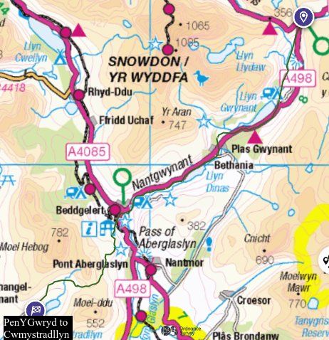
For a road that is listed in the Antonine Itinerary parts of this route remain elusive, despite the abundance of milestones associated with it. Most of it coming up from Canovium/Caerhun to Bwlch Ddeufaen is well established, and a milestone was found in 1954 in the vicinity of SH71987155, GAT4688. This relatively high level pass (1375ft=419m) is historically the safest way of reaching north West Wales, since it avoids the difficulties of travelling down the coast from Conwy (itself founded by Edward I with the building of the castle) past Penmaenmawr and Penmaenbach, where there is a history of unwary travellers falling in to the sea. The prehistoric standing stones GAT523 suggest the Romans were not the first to use it as a long distance route. See my separate article Ashton’s Road to Parys Mountain. The same course is used by the National Grid powerlines established in the 1930s, and the wide well established track that is generally referred to as the Roman road on OS maps was utilized with some modifications to enable their construction. The route was also included in a turnpike Act of 1777, and possibly some work undertaken.
Travelling west from the top of the pass there are indications where the older route is visible to one side or the other of modern track. By a ford SH70307207 there is an upstream zigzag, and W of this the earlier course is marked by a hollow on N side of present track. After a second ford at SH69927222 the modern route bears to the south uphill, crossing the shoulder of Yr Orsedd SH69307224. However 1891 marks a separate track to N, following the contour in an arc above the more direct stone wall up to the crest at SH69207251. All that is visible on the ground is a sheep track, but this might reflect the presence of drier ground at the outer edge of a filled in terrace. It is no longer marked as a path.
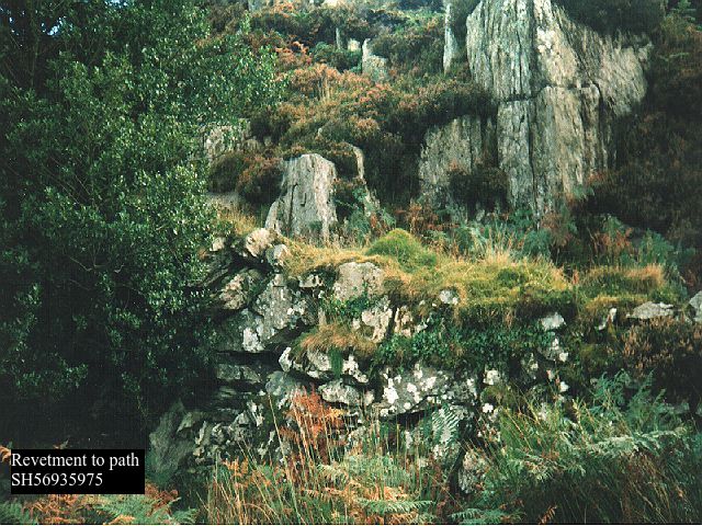
I walked and described this variation before the road was proved along this route by excavation at SH69437236 (GAT 217571), the crest seems significant because it an excellent aiming point from Gorddinog below, a clear saddle in the profile of the spur of the mountain. The three milestones found on or near the Gorddinog route, two at GAT4066 SH67907295 (there is a replica in the field of one of them), 2nd and 3rd centuries, and at Madryn SH66887338 GAT368 (“possible milestone”), plus its very clear military advantage going down a spur of the mountain with extensive views, seems conclusive enough.
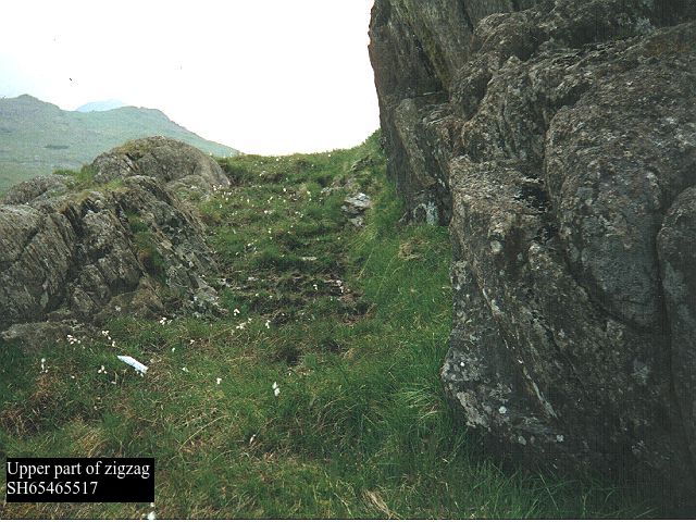
At this point Margary’s text seems confused, because he refers to a narrow terrace zigzagging down to Gorddinog. His source, it is unlikely he would have walked it himself, is Hemp, and that text, which describes what was known of the road at the time, but in the reverse order, clearly states the route via Gorddinog because of the milestones GAT4066, which were discovered in 1883, but it doesn’t mention the zig zags. I suspect what Margery saw were the zigzags above the end of the tarmac lane SH67607160, where there is now a small parking area. Even now some OS maps mark them as the course of the Roman road. Such a series of zigzags is a familiar feature of packhorse trails, eg above Beddgelert SH58644709 and elsewhere, and these are narrow and slightly hollowed, with no evidence of a constructed road. This line is littered with cairns, enclosures etc of uncertain date, so the route may even have existed before the Roman period. The tarmac lane which goes down via Bont Newydd and on to Aber is referred to in 1652 GAS XQS1652/156, where it is called “hwylfa gogvfryn” (? halfway valley)
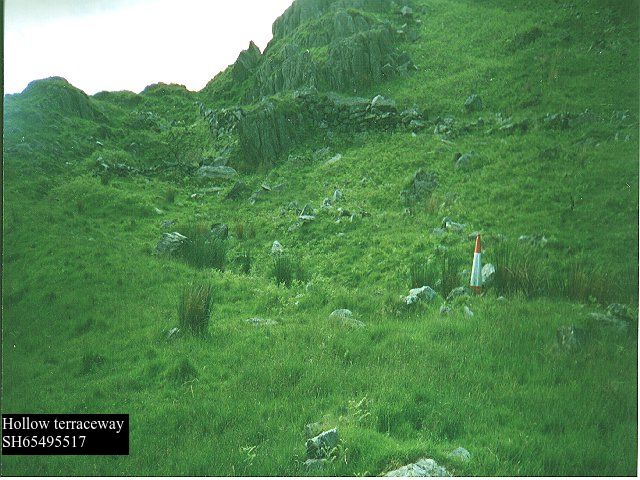
Returning to the direct route, there is a track continuing the line down from the spur although it curves away N at SH68857272. The straight on course is very steep although it does show from below as a grass sward in the heather, so there might be metalling underneath. Either that, or a small zigzag as shown on 1891. A wall comes onto line at SH68797269, and the route is marked as a footpath on 1891 and right of way on current maps , and as a road throughout on 1838, although noone seems to walk on it now, due no doubt to its inaccessibility further down. From SH68357285 on it develops as a very wide deep hollow way into which rocks to clear the surface for pasture have been dumped, petering out at SH67967309. The right of way to S at this point, which does have a stile, goes through a wood to Rhiwiau Isaf, a former riding school now a guest house. But the wall goes straight on to a T junction at SH67867330, although the ground is now featureless. Beyond the junction there is a right of way running at right angles, but there is no path and it is blocked at SH67757327 by a barbed wire fence. Below the fence however a wide slightly hollowed terraceway continues down the hill turning slightly N of W, and is accessible from the by road below by a stile at SH67607322. This runs out into the field where there are no visible traces, presumably the lane running down to Gorddinog roughly corresponds to the course of the road.
Once the low lying land is reached, we part from the route to Anglesey across the Lavan Sands, and there are no obvious traces, apart from the milestone at Madryn Farm already noted. The terraceway at Pen y Bryn SH65707283 GAT11168, is considered to be an early version of the turnpike. Abergwyngregin has a Norman motte and bailey GAT36302 SH657726, showing that a route existed in the mediaeval period.
There is a footpath leaving the village SH65617259 and curving round the hillside to the farm Henffordd (“old road”) SH65227232 From this point on there is a succession of evidence running SW, and seen from vantage points on the A55 below the guiding principle seems to be that the line runs in the angle between the mountainside and the coastal plain, which is often the break point between cultivation and rough pasture. There are a number of farms on this line, whose only access now is by individual tracks from the N, which could be of significance. From Henffordd there is a line of very large oak trees, the footpath runs on the S side of them with a terraceway (although it looks to have been modified by modern use) then a field gate at SH64807210. If approaching from the opposite direction, there is a wicket gate slightly to the N of this, don’t use it because although it might seem to be the footpath there is no (legitimate) way out of the succeeding fields. Nothing evident behind Glyn farm, there is a footpath running SW of the building and on to Plas Nant which is featureless in itself, but presumably is a memory trace of the road, because the field boundary at SH64557180 has evidence of a ruined terraceway.
Nothing clear for next half mile (unless the boundary of Crymlyn Oaks wood has evidence, would need landowner permission; similarly in fields between Crymlyn and Gilfach). Then at SH63207142 there is a field boundary, with wicket gates and footpath on N, lower side. However, an earlier edition of OS shows the footpath on the southern side (but 1891 shows nothing), and there is a clear terraceway running parallel with the boundary here. After a break in the next field it is again seen W of Tan yr Allt at SH63907129, marked as a path on 1891 but not on modern maps, then there are near continuous boundaries through to Tan y Marian which are not accessible by public path. At SH62407089 the line crosses a by road which climbs very steeply up the hill to S through a small valley, and represents a drove road from Anglesey via Aber Ogwen through the Carneddau. At SH61987057 there is a clear terraceway by the field boundary, there used to be a house here according to 1838, which may be why the adjoining wood is still called Tan y Marian Bach on OS. A footpath comes up from Talybont onto line at SH61687022 and becomes a terraceway in edge of wood opening out to a walled track turning away from the alignment and going to a T junction at SH61626987. The track it meets seems to be a variant of the current minor road from Talybont to Llanllechid. There is then a FP over a footbridge over a stream at SH61606972 which is clearly not now on the line of any “road” but may be a memory trace? Coming up from the bridge to the present Llanllechid road there is a minor road opposite going to Tyddyn Isaf farm. What is now the accommodation road for Tan y Marian remains on the alignment, but of itself looks modern, and there is no obvious continuation on the opposite side of the Llanllechid road. This area needs more interpretation, the stream though small is quite a sharp drop and further W becomes marshy, which may help explain the lack of clarity.
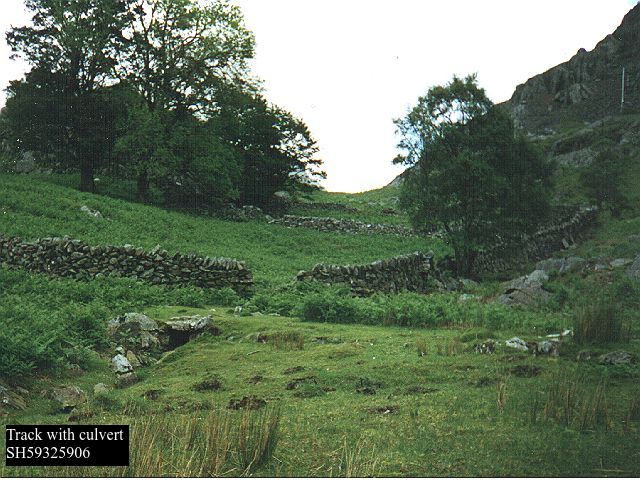
At SH60976968 it looks as though a hollow way coming down to a marshy area has been “adopted” by a stream, then there is a track with an old quarry on S side going along field boundary to road at SH60816953, which is very nearly on the same alignment as that approaching Tan y Marian. Beyond the road is the well-known C15th manor house of Cochwillan (spelt as Cochwinllan on 1891) SH60696942 GAT3670 , and on the far side of this at SH60626938 a blocked path goes into Coed Cochwillan, a wet hollow at first becoming a terraceway and taking a zig zag down through the wood to Afon Ogwen. The riverbanks are quite easily negotiable hereabouts, SH604693 but very steep to N & S, so it would be a good place to cross. Evidence there used to be a road and bridge crossing this stretch of river is provided by GAS XQS/1660/164, which is a presentment for repair of an unnamed bridge over the river Ogwen, flowing between Corrion (Cororion) and Bodvayo (Bodfaeo), situated on the road between Bangor and Conwey. Bodfaeo being the name of a mediaeval township encompassing Cochwillan. This is significant because it demonstrates an otherwise unknown bridge, and it is not an obvious route from Conwy to Bangor.
On the far side of the river the access track to Lon Isaf could represent the line, then at SH60206911 we cross the old turnpike from Capel Curig to Penrhyn Park, and a very narrow lane continues nearly on alignment with a small zigzag to get up a steep hillock at SH60076897. This is a typical Roman strategy, unlike the series of zizags on mediaeval packhorse trails already noted. Just short of Cororion the lane turns S, and an accommodation road continues to the farm. Beyond this a terraceway can be seen at SH59526853, then a double boundary fence continues through Cororion Rough for nearly half a mile, both on 1891 and at present. After a slight gap and nearly the same alignment at SH58956820 there is an access road to the house Pont Felin Hen (“old mill bridge”). If you access the disused railway line, now a cycle route, between these two points, a wicket gate which would lead to the access road can be seen in the wall to the W, SH59046826, opposite on the E wall a corresponding access point has clearly been blocked with stone work, this strongly suggests that a right of way originally came through here.
From this point the B4366 is now the road leading directly to Caernarfon, but although the route is a direct one keeping to high ground, the actual road is a modern one based on a turnpike, last upgraded in the 1980s. The significance of the route in general terms is that it ignores Bangor, which has of course been a church site and subsequently a town since the C6th century and as M notes it is geographically well placed generally on higher ground between river valleys with commanding views. First however the Afon Cegin has to be crossed, the modern road does so near Groeslon roundabout SH56236685 but by this time the valley is so shallow that the crossing is imperceptible.
The next possible evidence is a path running from Tyn y Friddth SH58176841 (where it is now diverted from the front of the house N to the rear) past Tyn y Friddth cottage to Pen y Cefn at SH57436795 which has evidence of construction, side ditches, and some culverts. For this to be indicative of the Roman route we would have to postulate a crossing of the Afon Cegin at around SH585682, by way of a dogleg from the previous alignment. Topographically it would be a perfectly viable crossing, and once Tyn y Friddth is reached the advantage of higher ground as noted by M is gained, but there is nothing obvious in the fields. It also comes closer to the site of the now lost milestone found on Ty Coch farm (HH pp35-36). At Pen y Cefn the track ends on a minor road, there is a field boundary going straight on for about 600 metres which aligns well with the route now established for certain by aerial photography and excavation from Pentir switching station on to Caernarfon: most recently by excavation in advance of trenching a new pipeline at SH55596712, which I saw on 30th April 2021 when it was being excavated by Brython Archaeology.
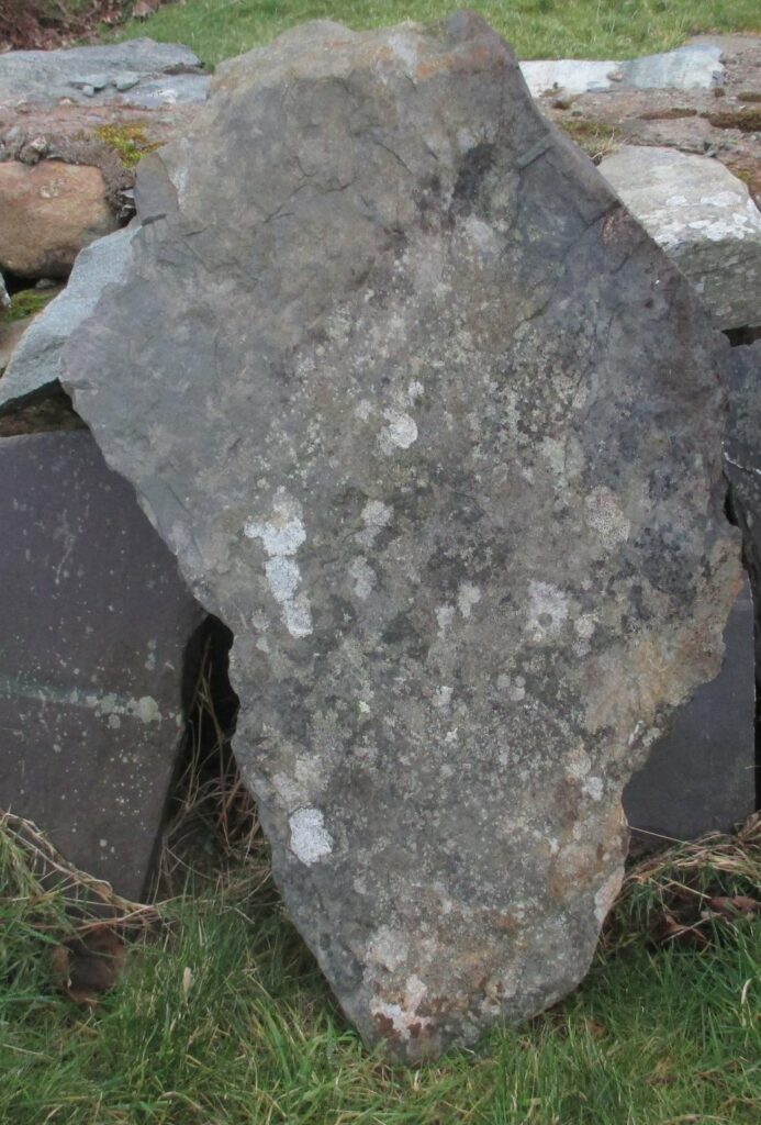
Yr Cymmrodor vol 33 p101, the report of the excavations of the Roman fort at Segontium in the 1920s, comments “In regard to the [discovery of considerable quantities of slate], Dr. Greenly observes: “Perhaps the most interesting circumstance in connection with the materials of Segontium is that the Romans discovered the now celebrated purple slates of the Cambrian system in Carnarvonshire, which have been so extensively quarried in modern times. The slate may be termed a “local” rock, in the sense that it occurs in the district ; but its nearest outcrops are five miles away, from which it is evident that the builders had appreciated its remarkable qualities. They used thick slabs of it for flooring, and thin ones for roofing, slates having been found which had been pierced for fixing on a roof. They do not appear to have obtained the finest and most fissile varieties, all the slates which have been seen at Segontium being slightly, though very slightly, sandy. This was probably because the finest beds tend to weather into smooth slopes, whereas the sandy beds are apt to outcrop in little escarpmental crags, and thus be much more conspicuous. No older record of the use of these slates is known, so that there can be little doubt that the Romans were the first to discover them.” I live adjacent to Dinorwig quarry, and own one such sandy slab.
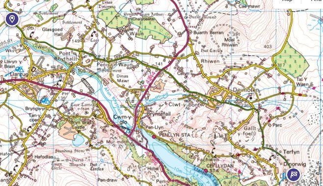
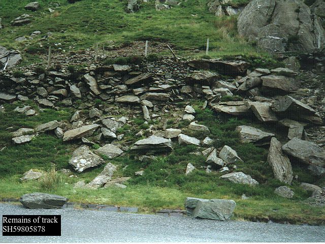
A Roman milestone was found in a group of buildings in 1798 at SH56456360 GAT2419. The inscription on it cannot now be confidently deciphered. In an area where large boulders for walling are so abundant it is hardly necessary to transport rock even a modest distance, it seems unlikely this milestone would have been transported several miles from the nearest known Roman road. Why not look at the road beside which it was found? – passing through Clwt y Bont and ignoring the village of Deiniolen (formerly Ebenezer) which grew up round the quarry access road built by the Vaynol estate in 1812. Before then this route was the only way of accessing Dinorwig itself.
Starting from the vicinity of Canovium – Segontium road at SH531648, there is a lane which goes straight on to Penisarwaun after the more important bus route to Llanrug bears S at SH53326445 and then continues on to Clwt y Bont. It appears on 1818, where it is described in Gothic lettering as “Sarn y cryiau” (? = bedding causeway) This is direct rather than aligned, although E of Penisarwaun it is “warped straight”, and is all but level. After crossing the A4244 (formerly B4547) the road passes the site where the milestone was found, and continues climbing gently until it comes to a steep pitch at SH57176319. After crossing the Dinorwig Tramroad of 1824 at SH57466309, the current main road bears N up hill, minor road goes straight on, and on S side at SH57576304 there is Tan yr Henffordd (“below the old road”), which looks as though it was originally a 2 roomed cottage now much extended. Then again, by Deiniolen Silver Band room, the more used road turns N, and lane goes on and immediately swings through a sharp upstream zigzag over river Caledffrwd SH57836296. The bridge here was rebuilt in 2015 after the old one collapsed in a major flood in 2012. That was constructed of huge slate slabs typical of the early industrial revolution. Prior to this there were slight traces of edge-on paving below the bridge on N side, maybe indicating a ford, but these disappeared in the reconstruction. At SH57956294 the road veers N round a mound of earth, but the S field wall goes straight on, and there is an old opening for a wicket gate in it halfway along the line. All this stretch from the main road, through what is now the village of Clwt y Bont, and including the zigzag, appears on the Llanddeiniolen enclosure award of 1813 (GAS) and 1818. On these maps the track then turns abruptly S at SH57976292, this still exists as a footpath, the road going straight on is not marked but logically must have been there. Bear in mind these maps do not show what were at the time considered paths, not roads. A small stream (now culverted) is crossed at SH58246284, then at SH58526282 it crosses the 1812 quarry road and goes very steeply up the side of a tributary of Caledffrwd, as a lane called Lon Bwlch up to a small windgap at the top. The terraceway is most pronounced at SH58626254, where a retaining wall some 8ft high is beginning to fall in. Another minor road is joined at SH58706231 and then continues S to a T junction with Lon Garret at SH58716195. The modern road then descends slightly to the village of Dinorwig, where it could have gone to Chwarel Fawr and Allt Ddu quarries, now landscaped and the destination of the 1812 cart road. Alternatively there is the very striking feature of Lon Garrett climbing across the mountainside until it disappears under the quarry tips at SH59526115. It is not obvious why such a line should have been chosen for a quarry road of the Industrial Revolution, when the main C18/early C19 activity is known to have been down below on the Tramroad at Allt Ddu; this upper area of the quarry being as far as is known a later development. The lower section of it appears on 1818, without the quarry at Garrett from which it is now named. It is then referred to by name in a sketch of Dinorwig quarries made in 1836 (GAS Vaynol 4190). Looked at from the opposite side of Llanberis Pass, it is clear the line is the only possible one on the hillside at this high level and has been surveyed to a very regular gradient. Does this imply there was older quarrying activity up here? The fort at Segontium used slate slabs at first, and later roof slates – is this where they came from? This is clearly would not be an aligned military road in the traditional sense. But classical authors refer to three different classes of road, much like our categorization of roads as A, B, or C. The most accessible text on the subject is to be found at https://www.perseus.tufts.edu/hopper/text?doc=Perseus:text:1999.04.0063:entry=viae-cn, there are Wikipedia articles and other sources as well.
The road Margary RR67 is attested as Iter XI of the Antonine Itinerary, which is the shortest entry in terms of the number of stages. Segontium is a well attested, excavated Roman fort and vicus, which has an afterlife in several Welsh legends. It is reasonable to think of it as the most important Roman presence in North West Wales. It was probably founded by the Roman governor Agricola in AD78 following his victory against the Ordovices. The tribal name survives now as Dinas Dinorwig, and thence as the village name which has migrated a few miles uphill. But this was not the first Roman presence here, since in AD61 the governor Gaius Suetonius Paulinus engaged with the “Druids” in a battle on the Menai Strait (Tacitus Annals 14.29). He then learnt of the Boudiccan revolt started in Camulodunum (Colchester), spreading to London and St. Albans. He had to return south in order to put it down.
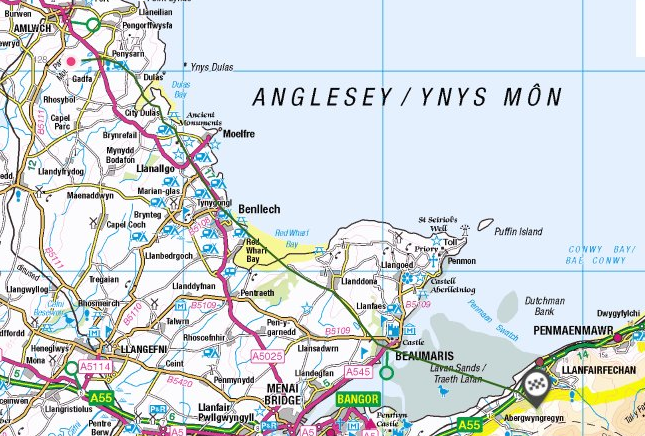
The Roman navy would not have been capable of conveying messengers and troops (even allowing for Tacitus’ figure of 10000 as an exaggeration) around the south western end of Cornwall in such an emergency. There must have been a route linking the Menai Strait and London in AD61, but where did that battle take place? I think we are in danger of being blinded by modern topography, most historians assume it must have been either Bangor Ferry, or Moel y Don. But it is well attested both by literature and maps that the main crossing up until the inundation of Lavan Sands, was at what is now called Beaumaris. That is why Edward I built a castle there, to dominate the crossing, just as at Conwy and Rhuddlan. The road over Bwlch y Deufaen can best be viewed as a Romanized trackway, which continued across the Menai Strait to Parys mountain, as described by William Ashton. The section running from Gorddinog to Segontium was added some years later, when the latter fort/town was created in the latter half of the 1st century.
Extract from William Ashton, The Evolution of a Coastline (1920)
“Mr. Elias Owen writes about this road : — ” I well remember 35 years ago (circ. 1859) noticing the ridge or raised roadway then existing, and which there was every reason to believe was a Roman road, raised and paved, going over the sands, and which most likely ended in a ferry opposite Beaumaris.” An 1805 map (Laurie & Whittle, London) shows two distinct tracks to Beaumaris, the one commencing from between Penmaenmawr and Llanfairfechan. and the other from opposite Aber. [1795 shows the same configuration, with the more northerly line marked as a coach road]
Early in the 19th century the fine new coach road through Nantfrancon and the Llugwy Valley, by Corwen, Bettws-y-coed, and Capel Curig, diverted the Irish traffic to the Bangor ferry, the Straits being crossed near the spot selected by Telford, 20 years later, for the building of his great experimental Suspension Bridge. This bridge was opened for road traffic in 1826. Four years later the railway era was inaugurated, and in 1850 Stephenson’s great Britannia Tubular Bridge, about two miles west of the Suspension Bridge, diverted to the Chester and Holyhead railway the bulk of the Irish traffic which Telford’s bridge had been designed to carry. The way from Conway to Beaumaris was joined, before reaching the ferry opposite Beaumaris, by an ancient track which came from the Roman station of Kanovium, or Caerhun (five miles above Conway, up the river Conway), over the mountains through the high pass of Bwlch-y-ddeufaen, and descending to the coast through a narrow valley, Rhiwiau, on the Aber side of Llanfairfechan, opposite Bryn-y-neuadd. In 1883 two Roman milestones, of dates between 119 and 211 A.D. [see GAT4066] were found in this valley, proving by the inscriptions upon them that this road had been used by the Romans as a way of approach from Kanovium to the copper mines at Pary’s Mountain. This Kanovium track over the mountains is one of the earliest of roads across Carnarvonshire of which we have any knowledge. It was part of the Roman road from Chester through Denbigh, Llansannan, and Llan-gerniew to Segontium ; others think through St. Asaph and Bettws- Abergele ; the evidences are very vague. Near Careg Vawr (overlooking Llanfairfechan) the road forked, the left leading through Aber to Segontium, and the right towards Anglesey. The writer has taken some pains to trace the way on Anglesey taken by the Romans to reach the Amlwch copper mines. Precisely opposite the old road across the mountains from Kanovium, near Llanfairfechan, about 3i miles east of Beaumeiris on the Anglesey coast, the old way probably went between Penmon School and the sea ; east of Cornelyn, Llangoed ; above the Methodist Chapel and past the windmill ; then, after a sharp turn to the left, to the hill Marian Dyrys ; by Coed Cywydd Farm and Dinas Sylwy, and thence direct to Red Wharf Bay at a point nearly a mile below its head. Here it is joined by a direct road from Beaumaris, which would be an alternative way from across the Straits. Subsidence having caused the sea to advance up Red Wharf Bay to this extent, the old track is now submerged for about 21 miles of its course. On the opposite, or west, side of the Bay a well-defined road ascends from close to the north side of the Ship Inn ; thence by Llanbedrgoch and Penrhos Llugwy (where quantities of Roman pottery and coins have been found) to the Copper Mines at Pary’s Mountain. It seemed worth while to make this examination, as the support which it gives to the subsidence theory is incontrovertible. A marked characteristic of Roman roads is their directness, a condition well fulfilled in this case.
” The remains of a paved Roman way, according to ” Lewis, may be traced leading through Penmon, ** towards Llaniestyn.” (Williams’ ” Guide to the Menai Straits.”).
This submerged road, whose existence is evident to anyone looking at a detailed map of eastern Anglesey, must be reflect a time when sea level was considerably than it is now, and Penysarn (top of causeway) at the northern end SH459904 is a significant name. Beware of proceeding too far down to the inlets by vehicle on this road, it is very difficult to turn! Now we know that Parys copper mine was worked in the Bronze Age as well as by the Romans, it fits very logically as an ancient trackway like those running east/west further south across the Rhinogau.
This blog contains research about Roman roads and other old routes in northern Gwynedd, where I now live. I first learnt to read an Ordnance Survey map when I was about 6. Although I didn’t know it at the time, I crossed Margary RR14 at TQ35767332 every day in later primary and all of secondary school, to and from my grandmother’s home nearby. When I was 17 I worked as a volunteer at Lullingstone Roman Villa in Kent, so learnt some basic archaeology there. I met Ivan Margary once on-site, and started taking an interest in Roman roads, and communications generally, round about then. I bought the first edition of his two volume work, and must have read it pretty thoroughly over the years. My degree is in Latin, Greek, and Theology, including researching Byzantine liturgy, and my working life has been spent largely in childcare. Over the last 60 years I have walked many roads, Ackling Dyke in Dorset, Dere Street over the Cheviots, the service road for Hadrian’s Wall in some places, and lots of others. I’ve seen the Roman bridge at Piercebridge. But I am not a professional archaeologist, so I don’t have access to modern resources and techniques. What I am covering in the following pages is old-fashioned fieldwork, with some historical research and a smattering of modern technology. More to follow later.
In 1999 Edmund Waddelove self published a 300 page book on Roman Roads in North Wales. ISBN 0 950683 1 1. He was by then a retired surveyor for the Forestry Commission living in Ruthin in Clwyd and travelled extensively in pursuit of this retirement activity. I bought a copy from him shortly before he died at the age of 94 in 2013. Copies of the book can occasionally be found second hand or in libraries. The book is illustrated with drawings and some black and white photographs. There is a great deal of material involved and I have only looked at chapters 5 and 15. Not all of his grid references are accurate – I have some sympathy for this as I regularly have to proofread my own!
In Chapter 5 he proposes a route from Caer Llugwy to Bangor, including the turnpike route from Capel Curig up Nant Ffrancon to Llyn Ogwen, ie SH72075816 to SH66826051, on the south side of the Afon Llugwy, and draws extensively on Thomas Telford’s notes, which were available to him from the archives in Ruthin, to explain why Telford abandoned this route in favour of the present A5 to the north of the river. This southern route is a bridleway, now Lon Las Ogwen, and is of massive construction across a peat bog. It includes some impressive double slate lined culverts to drain the bog, which Waddelove does not refer to. The slates are machine cut and can only be a product of the Penrhyn quarry; although the Romans did use slate slabs at Segontium, that product is of a much more basic origin, and nothing like so substantial. It appears on 1818 as “old turnpike”, but 1795 shows an older route now marked by a field boundary which stays on higher ground around the southern end of the bog, and if you follow that you will find a more modest road construction, which must be the route built by the owners of Penrhyn Quarry to their new retreat in the country in 1798, what is now the National Outdoor Pursuits Centre of Plas Y Brenin.
So this “Roman” route is an early turnpike. It would be natural to think that the Romans would have used this route, if they needed to reach Bangor, but this settlement was not created until after the Roman period. Their focus would be Segontium on the outskirts of Caernarfon, via the Roman camp at Pen y Gwryd at the top of the Llanberis Pass, as detailed in chapter 15, see below. He also posits a Roman camp at Bangor, but this I suspect is because the main route to Anglesey is now through the city, whereas until the 18th Century it was across the now drowned Lavan Sands to Beaumaris,see my article Ashton’s Road to Parys Mountain There is an earthwork of unknown date and purpose at the highest point in the city, SH58087285, GAT45816, popularly known as Caesar’s Camp, but I don’t think much reliance can be placed on that attribution. Any more than a reconstructed “Roman bridge” under Pont Pen-y-Penglog on the A5 at the head of the Ogwen Valley at SH64916051, which isn’t mentioned in the archaeological records at all. Roman Bridge station at SH71315146 , which I have used occasionally, presumably refers to the adjacent Pont Sarn Ddu SH71125158 GAT4619 which is C18th in origin. Sarn Helen RR69 crosses the river 2 miles downstream. He does correctly identify two stages of construction in parts of the route, but this is consistent with the difference between the turnpike and the Penrhyn road.
In chapter 15 the author also proposes a road from Capel Curig through Pen y Gwryd to Llanberis and then Segontium. This is a better founded hypothesis, also hinted at by RCAMHW, 1795 , and the regular references to an “ancient trackway” on C19th Ordnance Survey maps. I know this route in some detail, although I disagree with Waddelove’s proposed route in several places. The crux of this route is the marching camp at Pen y Gwryd (GAT1479 SH66005575), defined and excavated in 1962.
“ The enclosed area is roughly 4 hectares, which is about half the size of a standard legionary camp and seems to have been designed to hold around 2000 men”, considerably more space than was available at the permanent Caer Llugwy/Bryn y Gefeiliau. This is a substantial effort, there is no dating evidence but it is at a critical point for controlling the environs of Snowdon. Logically it must belong to a period of conquest, ie late 1st century, there would have been no need for it after that. There must have been routes for accessing it, and although the current remains are rather fragmentary, and don’t match the “A” road status linking major forts in North Wales, there must have been a use. See my article Capel Curig to Segontium
Routes in Snowdonia/Eryri where I live are determined by the mountainous terrain. Prior to the Industrial Revolution, the area was sparsely populated and consisted of subsistence livestock farming; there is virtually no arable land, and therefore no ploughing, so that archaeological remains from 2000 years ago are frequently found little disturbed in the landscape. Apart from cutting hay, the population would be dependent on “Mon Mam Cymru” (Anglesey the mother of Wales) for arable crops. Prior to the Reformation, the main landowner was the Augustinian priory in Beddgelert, and it is only after the dissolution of the monasteries in 1536 that land and buildings passed into private ownership. Even in 1841 the church at Betws Garmon had a thatched roof and was in a state of collapse, resulting in it being completely rebuilt. GAT6907. Wheeled traffic was virtually unknown, even John Ogilby’s route from Welshpool to Caernarfon in 1671 was only 6 feet wide at Llanllyfni SH47055221 (personal observation), packhorse trails were the routine means of getting from place to place. Genetically the inhabitants would have been largely unchanged since the Iron Age. There is the occasional Norman Motte and Bailey, usually on a Roman route, (Dolbenmaen GAT161, Abergwyngregin GAT36302 SH657726,and most conspicuously Tomen y Mur built over the Roman Fort there GAT5099). There was intermittent English control after Edward 1st’s construction of Caernarfon Castle in 1282, but little change in the population. Generally there is only one viable route through the passes, and so we find even in C19th OS mapping “ancient trackways” are clearly marked, and still largely traceable, although deterioration is increasingly to be found in modern climate conditions. Sites going back to the Iron Age are regularly associated with them.
The construction of turnpikes began in the nineteenth century, making wheeled traffic possible. But even in the 21st century this mountainous area can be quite remote, one or two places did not get mains electricity until a few years ago, and mobile phone reception, broadband, mains gas, water, and sewerage are not always to be found.
It’s against this backdrop that I refer to two trackways of which I have personal knowledge, in addition to the possible Roman routes already described, Bwlch Rhediad and Pen y Gwryd to Criccieth, of uncertain and possibly older date.
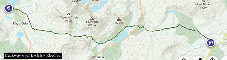
1. Bwlch y Rhediad
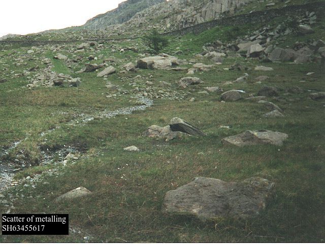
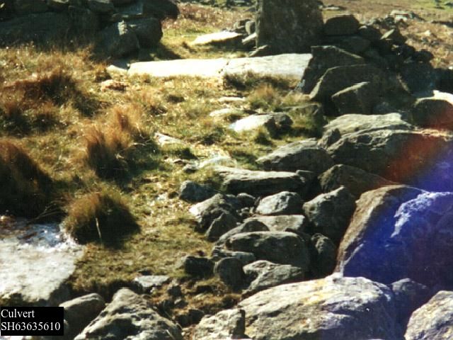
Evans’ 1795 map shows another “ancient trackway” branching to the East at SH65625284, now a footpath which climbs the hill very steeply indeed as a narrow hollow, crossing the A498 at SH65725272, where it becomes nominally a bridleway and continues the steep ascent to cross the skyline by a prominent tump of rock at Bwlch y Rhediad (current OS spelling) or Ehediad (both forms appear on maps of different dates). Thereafter it crosses the headslopes of the Afon Cwm Edno by Sarn Diwaunydd, where there are substantial stepping stones (see below) and gradually descends the hillside directly to Pont Sarn Ddu SH71125158 GAT4619. This route graphically illustrates what a “county road” of 200 years ago as described by Edmund Hyde Hall could mean. It is not shown on OSD of 1818 but reappears on OS 1838 as a path, and E of Sarn Diwaunydd SH68565272 as a road. It is difficult to imagine it would ever have been capable of sustaining wheeled traffic, and there is no evidence it is used even as a bridleway now; the ascent is so steep, rough, and overgrown I doubt whether any rider would wish to attempt it today. Nonetheless there is some scattered metalling, both surface gravel and foundation stones, and the occasional culvert. Beyond the pass it is usually a very rough narrow hollow, sometimes two, and 1891 again labels it “ancient trackway”. (GAT 8364). Across the moor the modern walker needs the very comprehensive waymarking that Conwy council has provided , however when you reach the Sarn there are some very substantial stepping stones (GAT 8266 which has photographs), again suggestive of a drover’s road – once you have got your feet wet getting over the bog immediately to the W of it; and there is some suggestion of a rough embankment where it enters forestry land, which has largely been cleared in recent years. The path becomes almost non existent here, you need to trust the map more than usual. Eventually you reach lower ground and come to Roman Bridge Station. Although it has few regular constructional characteristics, the author of https://www.megalithic.co.uk/article.php?sid=2146412751 who spent three days up here in 2006 argues with some force that it is part of a long distance drove road, and RCAMHW agrees. There are a number of archaeological sites in its vicinity. The route branching S via Moel Goch clatter bridge appears to be secondary version. By descending to the Lledr valley it does provide a means of communication, however primitive, between Nant Gwynant and Llanrwst/Conwy, but the creation of the turnpike, although a mile or two longer, would have made it obsolete. As Hyde Hall says “Before the present turnpike roads were made, [Beddgelert] parish was accessible only by rough and uneven bridle roads”.
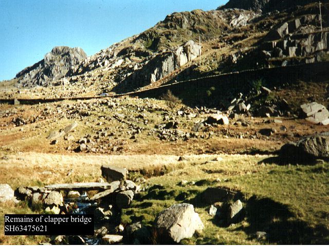
W of SH65625284 there was on 1891 a footpath through Hafod Rhisgl across the meadows to what Jenkins mistakenly called “Roman bridge” SH64875273. (GAT11719) The RoW has now been diverted more to the S away from the farm, breaking the immediate connection. This bridge is a substantial clapper bridge, extended following a change of course in the river bed, and a line of RoWs can then be traced from that point S and then W through Bwlch Cwm Llan at SH60575215, just to the W there is a brief section of made packhorse trail disappearing under a quarry tip, then Pen ar Lon, Rhyd Ddu, and probably Bwlch y Moch (“pig pass”, sure sign of a drove road) SH56125398, where by Jenkins account it crosses RR68 qv. Then down past Drws y Coed into the Nantlle Valley via a footpath which has now been adopted as part of the Snowdonia Slate Trail. From Penygroes it leads into the Llŷn peninsula. This section is much more fragmentary, but again shows evidence of a drove road.
2.Pen y Gwryd to Criccieth.
Leaving the Roman Camp at Pen y Gwryd, early OS maps mark the northern end of this route from SH65895547 to SH65845530 as being on the W side of the stream; although some very slight traces are to be found there, there is a more clearly defined track above the E side, coming down to the valley bottom in a reverse curve to cross Nant Cynnyd at SH65715502. Continuing S from there it can be clearly seen from the main road above. The whole trail is mostly a hollow way, sometimes two or even three in parallel, up to 2m deep with a wet bottom even in dry weather conditions. There are no signs of deliberate construction. It is no longer used as a footpath, and is now very difficult to walk, floods or no. For some of its course boulders have been piled up on one side or the other, whether to clear out the bottom, to funnel livestock, or as a marker, one can only guess. It crosses Afon Trawsnant at SH65585467, marked as a ford on 1891 and still easy to negotiate in dry weather, and becomes a modern well used footpath beyond that. After passing an Iron Age or Romano British hut site GAT881 SH65305415 just N of Cwm Dyli power station, it again fords the stream at the valley bottom and continues on the E side of the water as a hollow way. This stretch is no longer a footpath/RoW and becomes more indistinct as the meadows open out. After the modern campsite it merges with the A498 passing close to the site of Hen Capel SH64495169 GAT3399 and reappears on the 1891 maps as the approach road to Bryngwynant youth hostel SH64125141, and in the vicinity of Ysgoldy clapper bridge SH63505144 (GAT11680). which would be a dry foot pedestrian alternative to the ford marked on the trackway in 1891 a little further downstream at SH63285125, where it can still be seen. The approach to to the ford from the N is still a clear trackway below the main road SH63545134.
1795 shows it passing Hafod Y Llan farm and running in with its approach road to the present main road, which 1795 again shows it to have run on much the same course into Beddgelert. At the end of the village it passes the Royal Goat Hotel to the E and climbs the hills as tracks and hollow ways towards Criccieth. That section is still an RoW on the map even though it is now physically under the slate tips of Gorseddau Quarry SH57184522, not an easy route to negotiate, having been made redundant by the turnpike.
Even in the 1860s the evidence for this section of Roman road was rapidly disappearing. I rely on Jenkins’ account to look for remaining evidence, most importantly three bridges of some antiquity, and have also identified a possible alignment in Waunfawr as an alternative to the A4085, which is considered by OS to be a Roman road. For references see bibliography.
M’s description, which is based on the very brief description by W. J. Hemp Y Cymmrodor vol33 p171, is of a road approximating to the A4085 from Caernarfon through the Gwyrfai valley and then W of Beddgelert to Aberglaslyn, then the 1795 coach road through Croesor and across to Tan Y Bwlch, and so on to Tomen y Mur. Since Margary’s day, a direct route from Segontium to Traeth Mawr RRX95 has been identified to serve the Roman fort discovered at Pen y Llystyn GAT144. In current terminology RRX95 can be seen as a military “A” road, and RR68 as a “B” road, more direct but of later design with few alignments once it gets into the hills.
There are historical references to this route which show it has been used for centuries linking Caernarfon to Beddgelert, whose Priory certainly existed before 1282, and was probably much older than that. For instance Pont Peblig (ie a predecessor of the present modern bridge) features in a petition (see below) in 1651 (GAS XQS/1651/129) and a “crime report” in 1652 (GAS XQS1652/66). A version first appears in mapping in 1795 although it was not one of the the first turnpike trusts in the county. Instead early improvements such as the new skew bridge at Rhyd Ddu SH56945295 GASXPlans B/153 3/10 & 2/11/1778. were carried out as a result of a process of “presentment” or petition to Quarter Sessions for improving a county road, in which a number of petitioners applied for roads or bridges to be improved by the county surveyor, the cost being charged back to the parishes through which they ran. This procedure appears regularly in the surviving Quarter Sessions records, Many of these earlier bridge references are very brief, but by the C18th the procedure was sufficiently routine for “pro formas” to be made out in advance, with the details of bridge and highway added in a different hand. By later in the century we have detailed specifications for stone bridges laid out in contracts, most of the main bridges on the A4085 appearing in the 1770s (GAS Xplans B/143, 147, 150, 157, 170, 214), which were generally widened from nine to eighteen feet, which they remain to this day – rather narrow by modern standards – and made more flood resistant. Although the contractors provided warranties, apparently they were not always effective because problems recur in later entries. In July 1796 (GAS XD2/13096) a list of subscribers, led by local gentry and contributing some £270, is set up “towards the cost of widening and repairing the public highway from the town of Caernarfon to Pont Aberglaslyn, so as to be fit for all kinds of carriages, and to open a free communication between the counties of Caernarvon and Merioneth”. By 1802 Williams can say p43 “the road which is now well improved as far as Aberglaslyn bridge” (although not to everyone’s taste it seems, H p220, referring to Beddgelert, “much amendment in the choice of a level may I think be easily had along the road coming from Bettws” – unless this is is an out of date reference going back to before 1778. It was taken over by the Old Caernarvonshire turnpike trust as a result of the Act of 1810 (50 Geo III c52). Nonetheless it seems a petition to Quarter Sessions could take place even after a trust was established, eg with reference to the bridge at Beddgelert in 1814 (GAS XQS/1814/141) and elsewhere in the county (GAS XQS1795/93, XQS/1815/119 & 123).
1795 is the first reasonably detailed map of North Wales, although it does not reach the same standard of surveying as subsequent OS maps. It shows the present main road as a coach road much as now until Rhyd Ddu. As noted above, the bridge there was built in 1778 – which shows that the mapping of 1795 can be out of date, since the coach road it shows does not utilize it, instead it runs to the west of Llyn y Gader roughly on or near the line of the subsequent tramway, now a cycle route, eventually returning to the modern road just beyond Pont Glan y Gors, which is shown although not named. The turnpike development via Rhyd Ddu and Pitts Head means this route was abandoned by the time of the OS 2in to the mile drawings of 1818.
M and modern OS regard the present A4085 from Segontium to Waunfawr as Roman because it is in straight lengths as far as Waunfawr. The first part which actually passes through the fort of Segontium, appears on 1818 as it is now, save that it had a clear downstream zigzag at the crossing of Afon Seiont at Pont Peblig, a variation which has now disappeared under industrial building. However 1795 shows what appears to be an “unimproved” course at Caeathro, and again approaching Pont Crymant (ie the modern Waunfawr), which leads me to conclude that the present course is the result of a late C18th improvement survey across what was at the time common land. The fact that a now fairly straight modern road runs out of Segontium in the desired direction does not make it a Roman road, beware the turnpike!
However there is field evidence for a different aligned route running from Plas Glan yr Afon, SH50405980, which is of C17th origin (GAS 12153). through to Waunfawr. Possible routes NW of this point to Segontium are not clear, but this location is very close to the northward projection of RRX95 identified by Hopewell as GAT36427, so it may simply have joined it hereabouts, eg at SH49826018. Part of this alignment is now Lon Gwyrfai, and publicity boards assert this is “along lanes and tracks that date back to the time of the Romans”. Just before the Plas, which is now part of a riding establishment, a side stream comes from the NE at SH50355984, at which point the track has curved N to maintain a level course to cross it. There is clear evidence of a more direct route going straight across the small valley on the alignment, followed by a field boundary on 1891, andwith a footbridge at SH50305986, but this is not now accessible. Beyond the farmyard it becomes a straight level tarmac lane, maintaining an aligned course just above the main river valley, to a crossroads at SH50825970, where it was formerly met by a now derelict footpath that could represent another Roman route (see Llanberis to Segontium). The whole of the cycle path is now a tarmacked road which then turns N just before Caemabynyr SH51385961, to meet the A4085. OS mark a right of way (Waunfawr 35) past the house, and going straight on across the fields. In reality it is completely inaccessible. This whole area has become Snowdonia riding stables, a major tourist attraction, with yards, paddocks, CCTV, and polite questions asked of anyone who doesn’t seem to fit. I got thrown off a panicking pony here nearly 50 years ago. As elsewhere in Gwynedd in my experience, little used rights of way simply get eliminated, and the Council has neither the resources nor perhaps the inclination to resist “development”. Further on the map shows a field boundary, and just S of the lane to Fron Goediog at SH51825950 there may be some slight evidence of a roadway with edging stones. This then closes with another lane, to which there is no access, but after a slight change in alignment there is a field boundary marked continuing the line at SH52115938 towards Waunfawr. All this section of the route stays on the brow immediately above the small gorge to the S in which the Gwryfai runs, strongly suggesting a surveyed route. All features appear on 1891. This whole section is better aligned than the A4085 labelled Roman by OS.
South from Waunfawr we need to refer to Jenkins’ account p143, which disregards the coach road and A4085 completely. His book is dated 1899, although he says much of it is translated from an address given by a William Jones at an eisteddfod in Beddgelert in 1860. See https://biography.wales/article/s-JENK-ERW-1864 . It has recently been republished and should be fairly widely available.
“Several portions of the well-known road which connected Segontium (by Carnarvon) and IS (near Trawsfynydd) can still be seen in this valley. It ran from Carnarvon through Waen Fawr, and then south by river Gwyrfai, on its easternside, as far as Melin y Rydd in the vale of Bettws Garmon, where it crossed over to the other side of the river. It then passed right underneath Castell Cidwm, climbed up Gallt y Llyn (the slope above Cawellyn), where it can still be seen, and passed west of Llyn Y Gader by the hill called Y Gadair, to Glan y Gors. We see nothing of it again until we pass Meillionen, and then it is seenabove Ty’n y Coed, whence it can be followed in a field of Cwm Cloch. It can scarcely be doubted though now obliterated that it made straight for the front of the place where now stands the Royal Goat Hotel. From here it followed the same course as the present road, until near the old engine-house — now used as a hay shed — on the right-hand side of the road. It then crossed over Bryn y Felin, passing through a cutting in the rock by a little tower, and crossing over the very mouth of an old copper level, to emerge once more into the main road, about ten yards south of the third telegraph post from the old stamping houses on the roadside. We know nothing definite of its course again until we are right in the Pass. Some think that parts of it can be traced on the rocks above the road. A part of the embankment approaching the old bridge of the pass is still visible. About a dozen or eighteen slender fir-trees grow on it, drawing their moisture from the impatient stream that hurries by. Some five yards beyond the Aberglaslyn Bridge, on the Nanmor side, we see an old cutting above the road, on our left, which marks out its further course ; and here we shall leave it at present”.
In 1845 Bransby p52 also described “vestiges of a Roman road called Ffordd Pawl…the celebrated road which passed by the edge of Cwellyn Lake”.
Following this description, we find at SH52535925 the alignment already described is picked up by a narrow lane shown on 1818 diverging from the main road and continuing on the NE side of the valley, whereas the present main road crosses the river and runs parallel to it on the SW. 1891 records a milestone at this junction “Treflan 4” although it is in fact one mile. It is no longer in evidence.
From Waunfawr the next 3km of the Gwyfrai runs in a wide marshy valley, very possibly a filled in glacial lake, which this lane avoids, albeit by negotiating a number of side streams, and climbing through a windgap to the E of Garreg Fawr SH537584. There is a RoW branching W from it at SH53505863 and going down and round the lower W side of Garreg Fawr, but there are no field traces that it might ever have been a road. At SH53715388 the lane has a gate indicating no public access. There are mediaeval sites here, GAT refs 4203, 5078, 7321. A farmhouse dated to 1544 was removed and rebuilt at the St Fagan’s folk museum in Cardiff in the 1970s. Beyond the farm buildings SH53785821 the track now turns a right angle over a small stream. However 1818possibly continues the road going under what are now slate tips back to the A4085 by the church of St Garmon. It’s one of the several places where this particular drawing has unfortunately become quite damaged over the years, when I asked to see it at the British Library thirty years I was told it was too fragile to be brought out for viewing, so we have to manage as best we can with the digital image now available online. Lidar image now available seems to support this route.
The track turning right, which the occupants of Treflan are anxious to tell you is not a right of way, turns sharply to the E and is well constructed as might be expected for a mine working, and eventually splits into several versions approaching the ironstone mine known variously as Silurian, Ystrad or Betws Garmon SH542577 (GAT 20549), which has been worked like a copper mine on a lode of ore in the Nant Ffrancon series of mudstones, creating a long gash right up the hillside, very striking on the ground but barely detectable on the maps. I have tried several times to find evidence along the mining track and going back down to the valley without success. The whole area is now very overgrown and difficult to navigate, and the paths are effectively derelict..
At first sight this route from Waunfawr to Melin y Rhydd seems improbable. In comparison with the present main road, it seems rather a detour, the route has climbed some way above the valley only to come down to river level again but on the positive side it avoids a large expanse of flat marshy ground below, which must have been a lake at some time in the past. And a route must have existed by 1544 to provide access to Treflan .
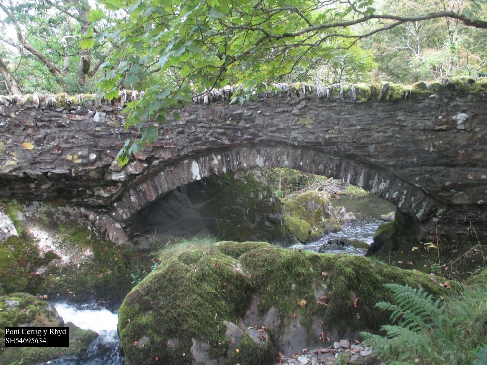
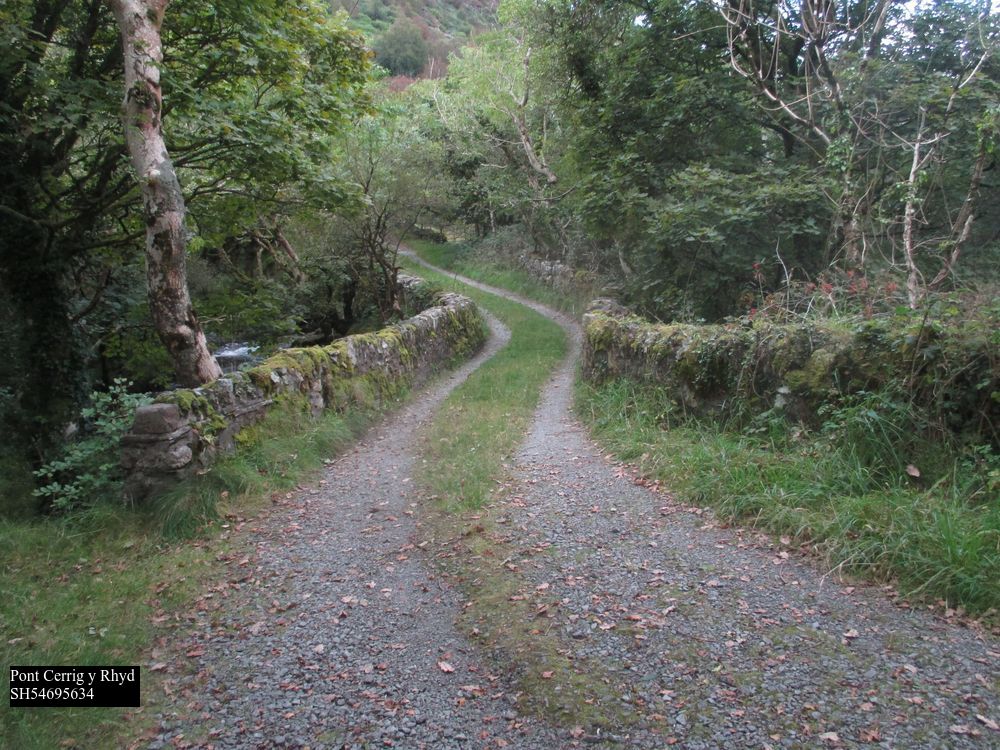
Beyond Betws Garmon church, it must have followed the A4085 or something very similar, in the main Gwyrfai valley now runs SE as a narrow trough exiting from Llyn Cwellyn, with a “pinch point” between crags at SH547563, the Melin y Rhydd of Jenkins’ description, “where it crossed over to the other side of the river”. There is indeed a bridge here, Pont Cerrig y Rhyd GAT63274, Grade II listed, 3m wide, which is shown on the undated engraving of the now demolished Nant Mill (GAT 6492) GAS XS/3092/2. The mill is marked, but not the bridge, in 1795 and 1818. This substantial bridge is quite unnecessary for the modern access to a couple of houses and a footpath,
The RoW following the track turns (little used) W at SH54595628 up the cwm into the mountains. Currently (April 2023) it is closed on account of fallen trees. The track, prominently signed as “private no access”, continues S to Cwm Bychan farm SH54585600, where it ends. There is nothing now beyond that in the fields until Castell Cidwm is reached. M doubts the possibility of this because he seems to think there is no room between lake and mountain at the northern end, but this is not the case, there is a terrace/RoW on this side, which could answer to it. OS maps show the current water level of the lake, now a reservoir, to be three feet higher than in the nineteenth century.
In its present form the northern end of that track is blocked at Castell Cidwm slate quarry SH552552 (GAT 20185) by a barbed wire fence extending in the lake to deter walkers going any further, but 1891 shows a track curving past the end of the lake (and therefore over Afon Gwyrfai) to the main road. To the S the footpath of 1891, (but the southern end a road in 1838) which was in open moorland at the time, is still evident and at SH55295518 appears on a shallow terraceway 5m wide, which corresponds to Bransby’s description.
It is soon overlaid by a modern forestry road running to the end of the lake, but where it drops down to the camp site at the S end of the lake SH56575408 a slightly hollow lane can be found along the wood edge continuing the alignment to a ruined building SH56735382 and out into an overgrown meadow where traces of a terraceway continue at SH56775376, most clearly observable from the main road below. Beyond another ruined building a stone pillar for a gatepost at SH57025342 would mark the same line, then the waste from Cwellyn slate quarry precludes any further evidence. This line would bring an older road back to the 1795 coach road at the T-junction just above Rhyd Ddu bridge SH5695296. In view of Jenkins’ description below, it could be regarded as a later variation of the Roman route, eliminating the climb to Bwlch y Moch.
However Jenkins already quoted states the Roman road “climbed up Gallt y Llyn”, which implies we should be looking at a higher route now represented by the bridleway Bettws y Garmon no. 38 shown on modern maps climbing to Bwlch y Moch, there is a now very degraded path roughly corresponding to this line crossing the steep slope as a terraceway. It is obstructed by fallen trees, but still sometimes used by walkers from the camp site. It will become quite impassable in a few years time. This route does not appear on any OS maps at all until RoW information is added in 1971. The definitive map, as is regularly the case in England and Wales, does mark out a slightly different route from this course, but there is no evidence for that on the ground. The last few metres of the track has been obstructed by fallen trees until the exit from the forest is reached at SH56135400, where a wicket gate (recent replaced with a “kissing” gate)
originally allowed passage through the stone wall. Crossways there is another RoW coming up from Planwydd by the camp site SH56795397, used by modern walkers to access Craig y Bera SH543542, which in 1891 came through the same gate, 1795 shows this route as a road running down into the Nantlle valley, ie the predecessor to the 1810 turnpike/modern B4418, and this is generally recognized now as an east-west packhorse trail. The western section is now part of the Snowdonia Slate Trail. See my article on Bwlch Rhediad.
Bwlch y Moch gives a good view of much of the surrounding country; in addition to Jenkins’ comments, the route is more direct when 1795 is seen as the southward continuation rather than A4085, and it gives easy access to Drws y Coed copper mines if they were active (possible but unproven) when it was devised. The hypothesis that this could be the original course seems therefore to be a reasonable one, but the lack of any confirmatory field evidence is frustrating. If correct, again we have a road that chooses high ground, not valley bottom, as its preferred route.
Beyond the pass the bridleway is mapped coming to an abrupt end close to the shore of Llyn y Dywarchen, but it does not appear on 1891 and it cannot now be traced on the ground, except for a vague path created by modern walkers to get down to the lake. 1891 does show a footpath going slightly E of S, through the now abandoned farm of Llyn y forwyn past the E end of Lyn y Dywarchen. This lake was famous even in John Leland’s day for having a floating island. It’s size grew considerably when it was converted into a reservoir for Drws y Coed copper mine in the nineteenth century. The 1891 path came down to the present road at SH56275290. No trace of this path now remains in the peaty ground and the S end of it is steep and awkward. However, later OS 6” surveys show an alternative path a little to the E, and this is reflected by gates in the walls at SH56415277 and again at an oblique angle to the present B road at SH56415278. The southward continuation from the latter point was in 1891 the only access to the house now called Drws y Coed Uchaf SH56475269 GAT83656 and such a route would give a connection straight into the 1795 route described below. It has only been during the C20th that the farm name migrated to this site, originally it belonged to the building by the dam on the B road at SH55905332, where the name makes better sense as a pair to Drws y Coed Isaf in the Nantlle valley
————————————————————————————————————————
From Rhyd Ddu the A4085 is as now from 1818 on, straight to the top of the shallow pass at Pitt’s Head, with the Welsh Highland Railway taking the same course first on E and then to W. For the origin of the name Pitt’s Head see Jenkins p152 – it does not refer to the top of the pass. The modern A4085 crosses Afon Colwyn by Pont Caer Gors, SH57585091, but 1818, 1838 and 1891 show a by road leaving here and running on the W side of the river parallel with the present main road. This is still technically a public road leading down to a car park, and then a drivable track running down past Hafod Ruffydd Isaf to its own crossing of the Colwyn at Pont Hafod Ryffydd or Pont Glan y Gors (1891) SH5749495, rejoining the main road as a tarmac lane a little further down. The main road is a slightly longer and gentler ascent, and does not appear on 1818, demonstrating that it is a “turnpike mk2” and the by road “turnpike mk1”, just like the A498 coming up to Pen y Gwryd from the S. This is confirmed GAS Xplans/B153, which is a contract with the Quarter Sessions clerk dated 3rd October 1778 to build “a new bridge over Afon y Gader at Y Rhyd Ddu [see above] on the new road leading from Quellyn bridge to Pont ar Golwyn”. The latter must be what 1891 calls “Pont Hafod Ryffydd or Pont Glan y Gors”, since 1818 shows the only other bridge over the Colwyn, Pont Caer Gors, did not exist at the time. The 1778 contract for Golwyn, GAS Xplans/B143, is to repair the existing bridge, not make a new one, and similarly for Quellyn GAS Xplans/B150, showing that the other parts of the present road antedate the modernization. A Pont ar Golwyn, which must be the same, is referred to in 1660 (GAS XQS/1640/M2).
The 1795 coach road shows a more circuitous winding course going W of Llyn y Gader. This is about ¾ mile longer than the present road, nonetheless the mileage figures from Caernarfon on some editions of 1795 are located at the current turnpike milestones, ie they reflect the shorter route not the longer one, presumably because the survey was done prior to 1778 and the mileages added later. The original route coincides with Jenkins p143 “[Roman road] passed west of Llyn y Gadair, over the hill called Y Gadair, to Glan y Gors.” Just above the bridge the B4418 (itself turnpiked around 1810) branches from the A4085, then at SH56685263 the modern road turns sharp right, and 1891 records a “tablet” at this point with mileages to Llanfihangel and Dolbenmaen – this refers to the “bridlepath” that goes on up the hillside, through what is now forest, and ultimately into Cwm Pennant by way of Bwlch y Ddwy Elor (“dark and magnificent passage” H p232, GAT 9648-9659). This pass is generally regarded as an “old” route although there is no evidence of construction going up the hill on this side, it is a footpath rather than a proper bridleway, and is currently in quite a dangerous condition. It does appear to be the route described by GAS XQS/1735/41 & 42 “the bridge of pont Llanfihangel on the road between pwllhely and Llanrwst was in 1726 presented by the Grand Jury at the Quarter Sessions to be ruinous and out of repair”, and mentioned even earlier GAS XQS/1657/184 and XQS/1658/E/22. Since 1891 the tablet has been moved and is now set into the roadside wall back at the road junction in Rhyd Ddu, it is carved out of cut slate and is of the same type as those at Aberglaslyn bridge, and elsewhere. It is listed, GAT63276.
From SH56685263 this bridleway continues the line of the road as a modest causeway (road on 1838 as far as the stream) going straight on from the junction across gently falling ground to a small stream at SH56455246, which it now crosses by a vehicle-width platform of old railway sleepers, then climbing the hillside as a footpath. Nb hut circles at SH56235214 GAT597 “Roman”. Our line is nominally represented on modern OS by another bridleway (which cannot be found on the ground, and has now been deregistered) almost at right angles crossing a little further up the hill to the W. Presumably this is the route referred to by Bransby p52 “on the S side of Drws y Coed may be distinctly seen the traces of a still more ancient road, Mignedd, which forms a passage…to Cwm Marchnad”; and probably the same one marked on 1795 as connecting at Drws y Coed with the packhorse trail from Bwlch y Moch already referred, by ascending gently to the present B road at Bwlchgylfin. However it is not shown on 1818/1838/1891 and there are no obvious traces on the very marshy ground. 1891 shows a footpath starting from the head of the quarry tramway across the marsh by the lake, falling in with the modern RoW beyond Gader Wyllt at SH56475185, the second of the two small quarries. However, there are traces of two other routes across this ground, the first through a galvanized iron gate at SH56425237, from which a terraceway can be traced leading up to the first quarry Llyn y gader – this presumably was the access to it before the tramway was built further E. The second less distinct route is represented by a blocked Victorian era wicket gate at SH56355237, then a galvanized iron gate at SH56345224 followed by more railway sleepers over a stream, and a third set of sleepers across a watercourse at SH56305222. At the next stream there are no bridge remains, but a slight terraceway climbing the S side at SH56325210, followed by slight hollows or terraces at SH56375193, SH56425188, etc., although there has probably been some disruption hereabouts from slate waste tipping. A modern ladder stile at SH56425178 is the first evidence of the actual map RoW, then a terrace SH56445178 climbs away from the stream, apparently forming an upstream zigzag to get over the watercourse before turning S at SH56485180 on the line of a stone wall. This whole area is a shallow peaty hillside with impervious slate near the surface, and little or no boulder clay to soak up any water, hence the many streams.
The stone wall now runs almost due S for several hundred metres, with evidence of a road variously underneath or to one side or the other, evidently laid out using the road as a guide but after it had gone out of use. At SH56525178 there is a prominent sinuous hollow way – presumably the 1795 coach road – up to 2m deep on the E side of the wall which eases the climb up the hill, with a much slighter hollow immediately under the wall itself. A terraceway can be seen at SH56545167 forming the leg of another upstream zigzag to a watercourse which has had the peat removed to improve drainage, and in the bottom at a depth of about 1m there are clear traces of metalling
The opposite leg is a slight hollow SH56545164, 1891clearly showing this zigzag as the course of the footpath. More peaty ground follows with no distinguishing features. At SH56555144 the path passes into Beddgelert Forest. This is one of the older forestry commission sites, and much of this area has been ploughed, cleared, and in places allowed to regrow naturally, so that other than the access roads it is often impenetrable, and any field evidence undetectable; Our path seems to run in the bottom of a shallow hollow way until it joins a forestry road, SH56535127, waypoint 47 in the Natural Resources Wales pamphlet of Beddgelert Forest walks.Walking in the opposite direction this path can be located immediately by the waypoint.
I have recently revisited this route. The land over which it runs, which is open access land, has been abandoned, and apart from the wall and the hollow way of the 1795 “coach road” it has degraded into a morass of rushes and peat bog over which it is almost impossible to make any progress. All the other features I noted have disappeared. At waypoint 47 I discovered the closure notice of 2013, a large nonbiodegradable plastic panel, abandoned in the undergrowth, and retrieved it.
The forestry road is the modernized version of one shown on 1838, in which it appears to be an access road coming down from the old level and small quarry on Bwlch Ddwy Elor GAT9648, which was by the packhorse trail to Cwm Pennant referred to earlier. From waypoint 47 the forestry track continues the alignment of the old road SE to waypoint 63, SH56975079, where 1838 turns E to reach the main road at Pont Caer Gors. This whole section from Rhyd Ddu would have gone out of use once the turnpike was finished in 1778, and high rainfall and peat have rapidly obscured the original course.
Picking up from waypoint 63, on 1891 there is a footpath/wall (just wall 1838) continuing the alignment from waypoint 63 and then curving more southerly to reach Glan y Gors at SH57315013, a site now lost near the present forest car park at SH57355026. This whole section is now completely impenetrable forestry regrowth. There is a little used modern path from the car park down to the bridge, with some suggestion of a hollow way in the undergrowth immediately to the west, more obvious now on lidar than on the ground. Hereabouts the 1795 version of the route goes south east to Pont Glas y Gors and rejoins the A4085 to run into Beddgelert.
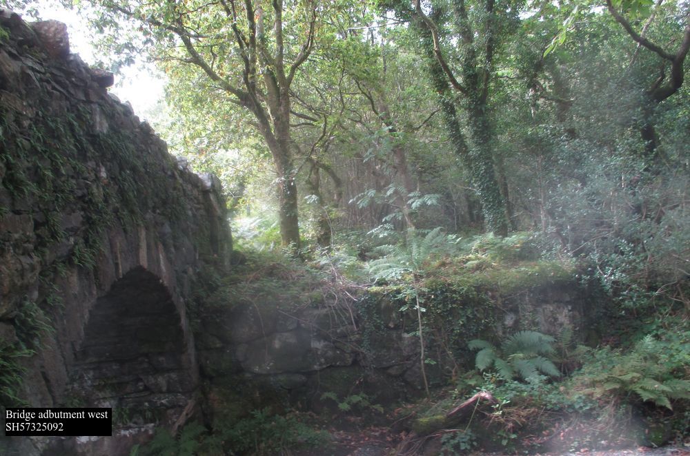
Jenkins p143 above talks of the Roman road going to this farmhouse, but no trace beyond. However to the west the present access road to Hafod Ruffydd Ganol/Isaf crosses just below the confluence of Afon Hafod Rhuffydd Isaf and Afon Cwm Du, by an arched bridge Pont Rhyd Cefyllau SH57325001 (GAT9674, waypoint 87). The bridge appears on both 1838 and 1891, and on each side there appear to be two intact dry stone abutments, very large fairly regular blocks, capable of taking a timber predecessor.
This is unusual and probably significant. The bridge itself now has a 5 ton weight limit. The arch appears to have been originally constructed in dry stone, with some subsequent mortaring. The track proceeding from the bridge is not straight, but skirts marshy looking ground and crosses the hillside below Hafod Ruffydd Isaf. From the bridge onwards it has been upgraded to the new Lon Gwrfai trail, so there are no historic traces until we cross Afon Meillionen ( ie “clover”) by way of a very substantial but unnamed bridge at SH57214919; this resembles Pont Rhyd Cefyllau above in that it was a single arch entirely of dry stone construction some 3m wide, but with no parapets. It appears to have been built within two abutments some 25m apart, again suggesting the possibility of an earlier wooden bridge albeit a rather long span. Like Pont Rhyd Cefyllau it is carefully sited just below a confluence but before the valley becomes significantly incised. Despite its obvious age it’s only reference in GAT is 83819 “unknown footbridge”. and I can find no name for it.
The creation of the new bridleway in 2013 has obscured it’s original features. Beyond the bridge the modern bridleway turns east into the forest to reach the forest campsite and railway station, rejoining our route further south.
West of the bridge a terrace turns to the north
and 1838 & 1891 then mark a path running into and through a double field boundary at SH57394872 through Meillionen farm SH57464881 GAT1953, which like many of the houses in the area is of C16-17th date, when freeholders acquired land following the dissolution of the priory at Beddgelert. This farm is not part of the forest, or on open access land, and now that the footpath through it has been declassified it is completely inaccessible to the public.
All the route from Pont Rhyd Cefyllau to this point is shown on 1838 as an approach to Meillionen itself. Through a stone wall, in which there is now no break or sign of reworking, 1891 then has a path running through Parc Ty’n y Coed as described by Jenkins, now untraceable, to the edge of the forest at a stream SH57754848, when Lon Gywrfai rejoins the route again. The stream is crossed by both a ford with what look likes non modern paving, and a modern footbridge.
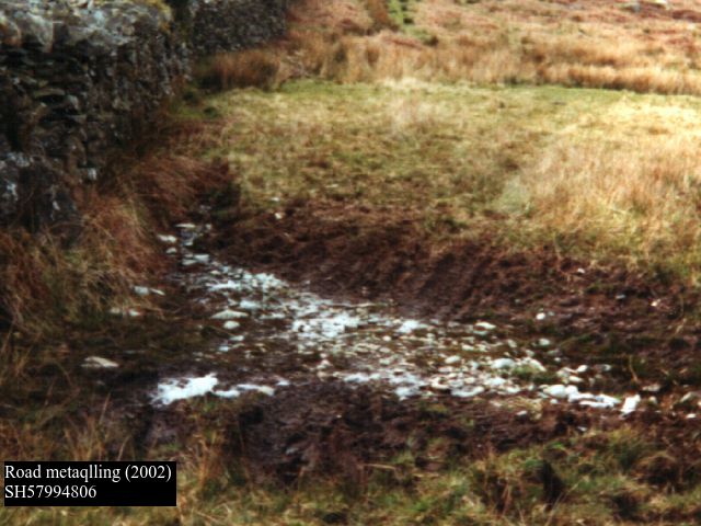
Beyond this the modern bridleway carries on S, and there are several substantial dry stone culverts, which may also not be modern. Some years ago at SH57994806, I observed slightly to the E of the modern route, that water had exposed a metalled surface with a slight terraceway coming down from the N. However, these fields are no longer grazed, and the growth of rushes means that I can longer find it even in midwinter.
This stretch coincides with J’s description p143 above, and additionally at p130 “Mr. Thomas the farmer at Cwm Cloch Uchaf] very kindly took us along a lengthy portion of the old Roman bridle path, which can still be unmistakably traced through three or four of his fields”.
Beyond Cwm Cloch Uchaf farm (which is of C18th origin), there is now a track and public footpath leading to Bron Hebog continuing the line for a while, but in fact neither this nor the house is present on 1891, not appearing until the 1900 edition. So it is not possible to make out any route beyond here, “obliterated” even in Jenkins time. There was an “undefined” footpath marked on OS maps running to SH58544793, now obliterated by a large railway embankment, and I can find no evidence now E of that point in Parc Cae Morys, which like much of Beddgelert is National Trust land. 1838 and 1891 do however show a roadway running from Cwm Cloch down the hill to SH54854819, over a “footbridge” at SH58474818, a modern concrete construction now, and then alongside the railway as a road running past the rear of the Royal Goat hotel to SH58704801. This is substantially out of alignment with the course from Meillionen, this could be because of a change of surveyors, which has been observed elsewhere as an unnecessary reverse curve, or simply that a more direct descent has vanished. Beyond the back of the hotel it is obliterated by the railway (both the current line and an earlier unfinished version) and an abandoned reservoir presumably for the hotel, which was built in 1801. It would pass by the modern cemetery at SH58734777.
The bridleway that crosses it here is of considerable age, appearing on both 1795 and 1818, and is a continuation of the “ancient trackway” running down Nant Gwynant (see separate article). It fell out of use when the turnpike was built in 1801 from Beddgelert to Tremadog, and like many others in Gwynedd cannot actually be used by either a horse or a cyclist, especially at the Gorseddau quarry SH57324519 where it was obliterated by slate tips in the C19th, as I discovered to my cost some years ago.
Our line then falls in with the path which becomes a terraceway running up to the entrance to Bryn y Felin copper mine GAT20527, in accordance with Jenkins p143 SH58964721. The features beyond that, including the remarks at p317 “near the bottom of the hill, between the wall and the river, is a cluster of fir trees … thriving on a small embankment, which projects towards the river at an angle of something like forty five degrees. The embankment is a part of the old Roman road, and it cannot be much more than twenty years since one of the abutments of the bridge was washed away…Just opposite this little grove lay the pool called Llyn yr Hen Bont… which was made possible by the strong weir which existed halfway between the Roman bridge and the present bridge” cannot now be identified.
Aberglaslyn bridge is at SH59424625 (GAT11683) and if you look underneath with some care, you can still see where it was doubled from nine to eighteen feet wide. Feature at Jenkins p310 is still exists “Some five yards beyond the Aberglaslyn Bridge, on the Nanmor side, we see an old cutting above the road, on our left, which marks out its further course.”
The coach road of 1795 passing through Bwlchgwernog, and reckoned by M to be Roman, is anything but straight, but see GAT 1509, 3098, 17541, 34536 for evidence that it could be.
Appendix – Gwynedd archives references to bridges Caernarfon to Beddgelert. In geographical sequence
1652 Pont Peblig XQS1652/66 May 6 DEPOSITION of Thomas Williams of Glan Gwnnis [Glan Gwna], aged about 35, concerning the behaviour of Robert Moore, a Scot or “Scots sonne”. He deposes that his daughter was travelling with Thomas Hughes of Nant whin, gent., Ellen his wife, Rowland David of Traflan, yeoman and Mary his wife, to T.W’s house at Glan Gwnis [Glan Gwna] when they overtook R.M. with Henry Williams, the son of William Williams of Wern, near Peblicke [Peblig] bridge etc.
1785 Pont Peblig XPlans B/214 1785 modifications to Pont Peblig, apparently the 1779 specification resulted in too much of a hump back, resolved by building the road upon each side to the level of the top surface. Other bridges received similar treatment, eg Pontrug GAS XPlans B/151. This is not the modern bridge of the same name, but a now lost predecessor downstream, see 1795and 1838
1776 Pontyr Cyrnant Waunfawr XPlans B/1701 Oct Pont y Crymant (also 159). Repair bridge. This bridge still carries A4085, and has been reduced to a single lane by traffic management.
1660 Pont Betws Garmon. XQS/1660/117 Jan. 8 PRESENTMENTS of: various bridges for disrepair. Appended: NOTE concerning order for Pont Bettus Garmon.
1787 Pont Betws Garmon XQS/1787/147 Oct. 1 PRESENTMENT of the jurors and body of Carnarvon that the bridge Bettws Garmon over the river Gwrfai was in a very bad state of repair and that the inhabitants of co. Carnarvon should amend it. Endorsed: A true bill. Present A4085
1778 Rhy Ddu XPlans B/153 3/10 & 2/11/1778. New bridge. Present A4085
1778 Pont Hafod Rhuffydd XPlans B/1432/9/1778 Golwyn. Repair bridge. Must be Pont Glan y Gorson the old turnpike route at SH57494995
1814 Beddgelert XPlans B/186 1802 Re repair of Beddgelert bridge, with accompanying sketch.
1814 Beddgelert XQS/1814/1491814 July 15 INDICTMENT preferred by John Jones against the inhabitants of pa. Beddgelert for not repairing Beddgelert Bridge. Present A498.
W ch 15 proposes a Roman route from Caer Llugwy (Bryn Gefeiliau) /Capel Curig/Llanberis/Segontium. I think it logical that there would be a road between the two forts, although I disagree with some of the details proposed by Waddelove. The earliest written record for such a route is found in 1660 at GAS XQS/1660/165 Presentment for disrepair of bridge over the river Lligwy [phonetic for Llugwy], called Pont y Glynn, situated on the road from Llanrust to Carnarvon. These records, (in which a defective bridge is summonsed to Quarter Sessions to account for itself!) haven’t made it to the Archwilio record. The entry confirms such a route to Caernarfon existed. This is the crossing at SH71845803, which is fordable in dry weather. I have seen it in full winter flood, and you would certainly drown if you tried to cross in such conditions. GAT66132 refers to the turnpike bridge carrying the A4086 in the same location. It is adjacent to the mediaeval Anglican chapel of St Julitta’s GAT6918 https://www.stjulittas.org. Although the chapel itself is deconsecrated, the graveyard is still in use. The original course of the track was to the north of the A4086 which passes Plas y Brenin, and is no longer a right of way. In the other direction the route to Llanrwst, now part of the Snowdonia Slate Trail, lies to the north of the A5. How the Romans would have reached this point from the fort at Caer Llugwy/Bryn Gefeilliau is not clear. Since it is on the S side of the river, it may not have had to use the ford at all. Alternatively GAS XPlans B/184 15/4/1800 Bontnewydd is relevant, since it refers to “Capel Curig to Bettws y Coed” at “Cyfyn issa”, that is Pont Cyfing at SH73435716, GAT74944, a route which passes the Roman fort and is usually regarded as being built after 1802 as a turnpike. Plans for a “new bridge” implies there was an older one it replaced
I have walked much of Ws proposed route through Dyffryn Mymbyr, described in 1891 as “ancient trackway” , and would add only that a painting in possession of a neighbour depicts a now lost bridge at SH66345599 which is consistent with this route. This valley is notorious for its high rainfall, as the Met Office weather station at SH70105705 will tell you. Another Quarter Sessions record 1815 Pont y Gwrhyd XQS/1815/119 April 1 Presentment that a part of the common highway in pa. Llandegai, beginning with a bridge called Pont y Gwychyd and continuing towards Capel Curig, 7,000 yds. long [4 miles, right back to Plas y Brenin] and 18ft. wide, is in a state of disrepair. This shows the new surface had failed within a few years. There was a turnpike at SH59205694 midway along this stretch, which is now Dyffryn Cottages, a holiday cottage owned by the National Trust. The inglenook in it has an oak bressummer beam, not slate, indicative of a pre Industrial Revolution date. None of the documentation for this stretch of the Porthdinllaen turnpike trust has survived, but clearly income was too low for the trust to maintain the road itself. Similar records replicate the situation at Beddgelert and Aberglaslyn.
Beyond Pen y Gwryd W states “the modern A4086 climbs across [the mountain] face to the top of Pen y pass; there are no signs of an earlier road within the few only feet on either side where such could possibly have been”. In fact, there is near continuous evidence just below the main road to the southwest which 1891 again describes as “ancient trackway”. Like most of these features, it is more easily seen in winter/early spring than in late summer, when bracken growth conceals everything. I first walked this section in 2002 prior to the establishment of a courtesy path on roughly the same line in 2016. The features are still visible but are deteriorating in the current very wet climate.
SH65715551 diverges from main road. Rather faint, hollow winding trail with occasional straighter terrace. SH65635543 and SH65505520 clear low terraceway damaged in parts, travelling slightly downhill E to W.
SH65435518 is a zigzag to get to the top of the shoulder of the hill, maintained by the courtesy path and clearly visible on satellite images.
There is then a succession of terraces and hollows until Pen y Pass is reached at SH64735563
1891 then marks trackway on S edge of A4086 but road widening has obliterated any traces, to point SH64585573 where it crossed at oblique angle and ran N of and below main road. A path is marked on 1891 and still on OS 6in 1930 edition, although not on present maps, but initially the traces on the ground are very faint and intermittent, slight terraces and/or hollows, hardly distinguishable were it not for the map evidence. This is boggy ground so remains may have been covered or washed away. By SH63985594 there is virtually no space between the present road and the river, and the line must be under the present road which has been widened from the 1831 turnpike. At SH63935596 1891 marks a footbridge which has gone.
Better evidence emerges as the line diverges from the modern road again with a terrace at SH64505575, with two adjoining hollow ways, then a partially collapsed culvert at SH63635610,
slight hollow at SH63625611, then a very clear terrace with a stone embankment at SH63555610. Where water washes over the line at SH63455617 there is a scatter of metalling, then the track must have crossed/forded Afon Nant Peris as on the OS map at SH63415623. To one side of this line there is a slightly perilous “bridge” of two very large slabs SH63475622 with one of the foundation slabs underneath partially dislodged, recorded on 1891 presumably a packhorse variation.
Further slight hollows or terraces are visible at SH63335632, SH63335632, SH63175651, but little evidence at the crossing of the sidestream Afon Bryn at SH63135652. marked as a ford on 1891. All along this stretch there is frequently a hollow path, no more than a foot or so wide, meandering in or beside the traces of the road. The line then falls in, below Pont Gromlech, with W’s photo p285, plate IV . OS maps cease to plot an “Ancient Trackway” from this point on.
Below this on to Nant Peris there is no evidence other than the present A4086, which is as near straight as the topography allows, and when a flood plain begins to develop, runs in the angle between it and the mountainside.
The next clear traces of a track on the southern side of Llyn Peris shows it must have crossed the river again, probably in the vicinity of the present “footbridge” at SH60375826, which now consists of a single very large quarried slate slab. There is a public right of way NE from here until the main road is reached again, then at SH59805878 there are the remains of a terrace by the fence rising gently until it disappears under the first of the slate tips and copper mine workings that together with the modern landscaping have obscured any signs for several hundred metres.
The next clear indication is the remnants of a terraceway leaving the modern lay by at SH59765878, with a fence on its lower side, at first largely cut away by modern roadworks, passing the entrance to a collapsed adit at SH59725881 and then becoming quite clear at SH59635884.
This route, which is presumably that referred to in W p286 note 6, rises some 50m above the modern road as it negotiates the only possible route through the cliff faces of Clogwyn Mawr other than taking what is presumably the turnpike route along the bottom of the cliff beside the lake. On the original OS the difference in height between 1831 road and lake is only 6 feet so it might originally have been effectively impassable. NB there is another largely destroyed terraceway arcing above the present road to pass in front of what is now Bens Cottage at SH59725883, which is a climbing hut and the only building to survive from the copper mine of that name.
Our route has a narrow spur to reach Bens Mine at SH59495889, where the adit is now blocked by a large rock fall, and passes across a waste tip to go under a wall at SH59645880. This section is no longer a footpath, and is not marked on 1891 although it is shown on 1838 as an access to the copper mine. Fortunately there is a sheep access through which intrepid adventurers can crawl under this very substantial stone wall. It then descends down a side valley towards the lake again, skirting a small boggy patch as a slight terrace showing mainly grass against the predominant bracken, and with some display of metalling in wheel ruts. Passing the abandoned farm of Gweithdy there are again grassy patches in the heather, followed by a sheeptrack, until the route goes under a wall and turns sharply to the left to cross a stream, where there is there is a substantial functioning culvert at SH59325906, close to and clearly visible from the present main road, with a road width about 4m.
There is a second culvert at SH59245905 before the terrace closes with the A4086 at SH59165906. This is the section referred to by RCAMHW p lxii. as SH59505903 to SH59265907, which appears not to have been transferred to Archwilio records.
At SH59045912 an access lane rises to the farm of Cwm Aelhir Uchaf, beyond which there is an unused and rock strewn terraceway leading down to the A4086 again at SH58895940. This last stretch is not on 1891 but is shown as a road on 1838. It is not currently shown as a right of way, although clearly someone thinks it is, because a wicket gate and steps have been constructed at considerable expense to gain access to the abandoned section when the main road was modernized in the 1970s. Beyond this it looks as though it dropped down past Cwm Aelhir Isaf almost to the lake shore, some suggestion of a road line can be seen from the opposite side of the valley, but there is no public access here. Back up at SH58685968 a track bears NE from A4086 (the junction has been substantially modified), and there looks to be a hollow rising from the lakeside to meet up with it. The road then passes W of Dolbadarn Castle as a terraceway SH58575976 which is cut through a slate outcrop, some 8 feet wide.
Beyond on the wooded knoll of Parc Bach there are several terraceways, which presumably reflect routes of different periods and/or for different purposes. On the top of the knoll SH58465974 there is a megalithic structure of unknown date and purpose, GAT4053 = “could be anything from prehistoric to Victorian folly”. Leading up to it on the E side there is a very steep terraceway with a double zigzag. This top would have been an ideal site for a signal station, since there is a clear view back up to the top of the pass on the one side, and on to Bwlch y Groes on the other. A second terraceway appears at SH58475982, clearly revetted then passing through two more small rock cuttings and over the remains of a culvert at SH58395980. The road appears to continue into the grounds of Royal Victoria Hotel a few metres further on. A third roughly parallel narrower terraceway can be seen a few metres further down the hill, presumably a packhorse variant again.
In the modern village 1795 and 1818 both show the main road crossing the Afon Goch at SH57626003. 1795 is not on a sufficiently large scale to show the approach from the SE, but 1818 shows it coming in at a right angle from the Dolbadarn Inn. At the time this was one of the first buildings in the village, reputedly built in 1802, and therefore not shown on the 1795 version. However, the other early building here is Capel Coch, which claims to have been built in 1777 GAT 63972 SH57666003. It could therefore be that the the original road to the SE was more direct, and was blocked off by the construction of this chapel and its Sunday school, which is now the village primary school.
The rest of the route is like deciphering a palimpsest
i) original route . It would appear that the original route headed to Segontium over Bwlch y Groes at a height of 1230ft, SH55705991 and subsequent routes progressively reduced the amount of climbing necessary around the flank of Cefn Du, the most northerly outcrop of the Moel Eilio ridge, until in 1831 the turnpike, essentially the present day A4086, made its way to Caernarfon rather than the Roman settlement. After crossing the Afon Goch at SH57666003. in modern Llanberis, a lane turns up the hillside at SH575356013, which is now the route of the Snowdonia Slate Trail. This rather abrupt turn avoids the route crossing small streams either side of it. There are one or two paths just to the north of this lane passing through Ty Newydd, with traces of a roadway at SH57075992, and at SH57085993 and perhaps the collapsed remains of a zig zag, (clearly suggested in 1891)and another in better condition at SH57055990. There is a terrace closing with the lane SH57025985, quite obvious 20 years ago, but now completely overgrown with bracken.
Just beyond is a path immediately to the N of the present road, which is accessed by a wicket gate at SH57015984. This access is about 1.5 metres above the road level with rough steps up, rather like the geological feature of a hanging valley. There are similar features at SH64545159 and SH58416072 in article Llys Dinorwig to Traeth Mawr, In both cases the later route has worn down sufficiently to create this effect. It then climbs the hill, initially obscured by gorse bushes but then zigzagging very steeply indeed, about 1 in 3 at a guess,
with evidence of a terrace cut through slate bedrock at SH56925977 and possibly a small quarry pit SH56925982. This climbs the S side of the Iron Age hill fort of Dinas Ty- Du SH56675986, GAT4034, and higher up the hill passes below a hut circle described as Romano-British SH56615980 GAT4032.
The path presents as clear grass as distinct from the bracken which has overtaken this hillside. In (increasingly rare) patchy snow it can be clearly seen from the opposite hillside above Llanberis. The path continues as a narrow terraceway slightly hollowed through the slate bedrock on that part of the zigzag which coincides with the dip of the slope, but otherwise largely unworn, occasional evidence of rough kerbstones on the lower side. At times there is residual evidence of side ditches, and also when vegetation is well grown in damp conditions, filled-in drainage channels can be seen running at 45 degrees across the path (a characteristic feature common to most packhorse trails through to more modern paths in the area such as Snowdon Ranger). The terraceway is clearly seen rising to a field gate at SH56735974, and a second at SH56665973. Beyond this the terraceway is again clear at SH56645973, about 6ft wide with side ditches, a typical presentation of a packhorse trail in this part of Gwynedd, (eg Fachwen SH57696169, Nant Peris SH60485904 3et al), and an edge stone at SH56526000 before closing with the existing track over Bwlch y Groes without further evidence at SH56545970. All this is marked as a FP on OS and modern maps, occasionally used by walkers although it has not been classified as a right of way. Coming up to the head of the pas an older line is faintly visible from SH56135983 a few feet above, ie S, of the modern track, used by pony trekkers, with occasional traces of an outer edge and small pits on the southern upper side. Across the hill to the S is a curious feature at SH56005924, a nearly flat shelf of boggy land about 100m x 30m on what is otherwise a very steep hillside, which might possibly be the remains of a long degraded quarrying of the rock which outcrops on this hillside, although it is here siltstone of the Nant Ffrancon formation, rather than the Llanberis slate strata on which the Industrial Revolution quarries are sited.
At the top of the pass the track becomes a tarmac road again – there is a small informal car park here. From SH53775993 to SH53275995 there is a RoW to the north of the lane, shown on 1891, which appears to be a collapsed terraceway. At the road junction SH53106011 it runs straight down to the A4085 at SH51845990. Beyond that a footpath continues the alignment to SH50785971 where it joins my hypothesis for RR68, qv. It is shown on 1891 and I have walked it in the past. However it is now completely overgrown and impassable.
ii)Variation via Maen y Llywd Uchaf . From SH57025985 the tarmac lane, which is still legally a public road although barely useable even by all terrain vehicles, eases this very steep ascent by detouring via ruined Maen Llywd Uchaf at SH56715948. The existence of this latter route from Llanberis to Caernarfon via Bwlch y Groes is apparent from the enclosure map of Llanrug parish, dated 1806, which although it does not show the whole stretch across Bwlch y Groes does show each end on lower ground marked “from Llanberis”, “to Caernarfon”.
iii) Gareg Lefain. At the junction at SH575356013 a lane carries straight on through a wicket gate at SH57306029, which looks like the usual packhorse trail, with a terraceway and a functioning culvert, rejoining the line of the other road shown on 1818 at SH57096036. This lane, now tarmac, passes the ruined Ty Du, GAT83226 SH56976031, the refuge of Bishop Goodman in 1647, “July 31. Petition of Dr. Godfrey Goodman, late Bishop of Gloucester. At the beginning of the late wars, petitioner’s whole estate was sequestered, and, as he had nothing to live upon in London, he was obliged to retire into North Wales, where he lived in a most obscure and mean manner upon the profits of a tenement worth £30 a year, which he had formerly conveyed to pious uses, but was obliged to resume for his own support; and now the Committee for the county of Carnarvon intend to sequester this small remains of his estate, which will expose him to absolute beggary. He prays the House to consider his case, as he is above sixty years of age, very sickly and infirm, to allow him some competent maintenance for the short remainder of his life, and to free his tenement from sequestration” He founded the Ruthin Charities which still survives, and is commemorated by “Goodman Street” in the village. This reference confirms the route existed in 1647.
The modern lane then climbs the hillside with magnificent views at SH566608, where Glyn Rhonwy quarry has been excavated to leave it isolated on a pillar of rock with tunnels underneath, and at SH55416151 a footpath diverges to the W and is eventually seen to be a packhorse trail GAT3875 centred at SH54346166. There is evidence of construction including at least one blocked culvert. It passes across Garreg Lefain and eventually descends to improved land via a zigzag at SH53356143. There is no further trace.
iv) Pen y Bwlch. Continuing up the very narrow tarmac lane which crests the hill at SH55126198, where 1818 shows a house Pen y Bwlch, The modern road now turns sharp left to make a steep descent down the hill. However a right of way goes straight down the hill with evidence of a hollow way. It rejoins the modern lane at SH54856206 and continues past Bryn Bras Castle GAT 4406, built in the 1830s on a mediaeval foundation, SH545625, not on 1795 but shown in 1818, and the lane continues past what is now the rear of the village of Llanrug to fall in with the A4086 at SH52906341.
v) Pont Rug (A4086). The layout of 1795 shows that Pont Rug is an afterthought, as evidenced by GAS XPlans B/151 “3/9/1779 Pont Llanrug – to amend the ‘new bridge’ built in recent years by raising the road at either end”. Before the new bridge, you had to reach Caernarfon by turning west through Caeathro, and approach the town via Segontium, which demonstrates how persistently the apparently Roman approach to Caernarfon via Segontium survived into the 18thC.
vi) Turnpike. Provision for a turnpike from Caernarfon through Llanberis to Pen y Gwryd, to meet the existing Capel Curig – Beddgelert etc road there, was made in the Turnpike Act of 1810 (50 Geo III c. 52) although it was not until 1831 that the work was completed. The A4086 N of Llanberis to the end of Llyn Padarn was built 1825-6. The accounts for construction of this stretch can be found at GAS XD2/13158, which is the account book of the agent’s payments, totalling £1677, to workmen on behalf of Lord Newborough for building the bridge at Penllyn and “some mile and a half of road toward Llanberis”. The road was further improved in 1984 by bypassing Cwm y Glo, as part of the improvement of A roads in the area to service the construction of Dinorwig Power Station. But even today, Pont Rug like other C18th creations in the area is wide enough for two cars with care, but not two HGVs. It’s also flagged on road signs as a weak bridge with an 18 tonne lorry limit, though I doubt it is always observed.
This was the succession of routes that was used to transport copper ore from mines at Nant Peris, and slate which we now know was shipped across Llyn Peris in the C16th. No wonder that Dr Johnson of dictionary fame (who, as it so happens, failed to graduate from my Oxford college) grumbled about the road when he visited Nant Peris in 1773, which he must have done via the Pen y Bwlch version. JMW Turner would have had the same experience when he visited in 1799, though there is no record of his attitude to it.
The first section of this proposed route is based on Jenkins 278 which refers to a “Roman bridle path from Dinorwic.” By this he would have meant not the present village, but Llys Dinorwig SH56256321 GAT2426, both (presumed) Roman and Mediaeval occupation. This is a scheduled ancient monument within a large caravan park. He does not describe the initial course of the route until “coming through the Pass of Llanberis over Gorphwysfa, down past Cwm Dyli by the side of the river, and through the land of Hafod y Rhisgl, until it crossed over at this point on “this old relic” [by which he meant the clapper bridge at SH64875272 GAT11719] It then kept under Gallt y Wenallt, along the brink of Llyn Gwynen, behind the hill between Bwlch Mwrchan (modern Mylchan) and the lake, passing Bwlch Mwrchan, and fording the river right in front of that farm. Thence it passed Plas Gwynant and joined the Segontium road — which we have already traced to the Bridge of Aberglaslyn — beyond Blaen Nanmor”. The bridge he refers to is not Roman in the conventional sense of the word, in the section ancient trackways I argue that it is part of a prehistoric east west route. Until it reaches Llyn Dinas it is a packhorse trail, as Jenkins suggests, a via vicinalis corresponding to a “C” road in modern terms. There is now documentary evidence that this classification existed in Roman Britain, see Bibliography. Beyond SH64565172 however, the construction is more robust, suggesting it was a route created afresh rather than being a existing route. It runs through the hills to Cwm Nanmor (Nantmor on some maps and not the same location as the hamlet of that name), continuing in a straight line down to the Glaslyn estuary and with further isolated traces to Traeth Mawr. 1795 evidences a coach road crossing to Harlech at this point
1795 and 1818 show no roads in the area of Llys Dinorwig at all, although the latter marks “Turbary” (ie the right to cut peat for fuel) around Rhydau Dion. Until what is now the A4086 was built in 1825, there was no access along the shores of Llyn Padarn on either side, so any path had to climb Fachwen and into what is now Padarn Country Park reaching a height of 731ft, 222m. The most obvious route connecting Llys Dinorwig to Llanberis Pass is a bridleway which runs from Brynrefail southeast across Yr Clegyr past Rhydau Dion SH56506261. This is now the only occupied house in the area, having been run by the same family for 50 years as accommodation for outdoor pursuits enthusiasts. In April 2024 there were a few cattle grazing, but no sheep, the land has effectively been abandoned. Past the abandoned Fron Goediog SH56716249 (4 people living here in 1851) a rough trackway climbs the hill on a substantial terraceway. It probably carried straight across some scrubland, since there is a path blocked by a tree at SH56826340, to reach Bron y Gadair SH56786227 (another 4 inhabitants in 1851). There is slight evidence of a hollowway to the left of the main path here. It then passes through a Victorian gate into a detached area of Padarn Country Park, and makes a right angle turn to climb to the top of the hill, coming down to join Lon Fachwen at SH56996197. Throughout it is a packhorse trail, although there is no evidence of culverting. The lane coming up the hill from the west here was built in 1824 GAS XD2/6619 to replace this route, and allow better access to slate quarries being developed on the hillside by the Glynrhonwy estate, and from 1840 by Vaynol. See my article on the Vaynol Estate in Lockdown on a Welsh Mountainside.
The route now becomes part of Lon Fachwen for about 800yds/730m, although there are some hints the original route may have been a little to the south. The modern lane then turns north to reach the village of Dinorwig, but at SH57696167 there is a packhorse trail with kerbstones in the grounds of PenyBryn. It then passes more deserted houses, with further evidence of a packhorse trail, until it reaches Cae Goronwy SH58126143, which I can remember as a ruin. It has now been illegally but successfully blocked by the present owners who have provided a diversion. It then crosses Afon Fachwen and climbs the hillside again, with evidence of a classic packhorse trail construction at SH57686168, the remains of 4 culverts, eg at SH58396074 & SH58176096, hollow ways SH58396075 and SH58366078, a “stranded” path SH58416072, and where terraced being revetted on the lower side with blocks of stone. The surface has been eroded by water action down to the bare rock. The culverts are of random stone and slate, so appear to be pre-industrial revolution. By “stranded” path I mean that at the junction of two paths the older one has been left stranded above the newer one, whether by design or erosion. Two other examples are to be found at SH64545159 belowand SH57015984 in Ancient trackways section Capel Curig to Caernarfon. The section in Coed Dinorwig is shown as a road 1795 leading to PenyrAllt. At the bottom of the hill modern slate workings destroy any evidence, but it would have linked up at Castell Dolbadarn SH58605979 GAT5550 to the trackway over Llanberis Pass.
Another possible path less well evidenced through Dinorwic Slate Quarry is represented by a right of way in danger of collapsing under the slate tips. There is a packhorse trail construction at SH60455906 but nothing else.
The section up the pass is described (in reverse order) at Capel Curig to Segontium
From Pen y Pass there is a track descending into the Glaslyn valley. It is now a RoW, there are hollow ways on it from time to time but its main characteristic is that it comes straight down the brow of hill between Afon Trawsnant and Nant Cynnyd, apparently with a zigzag on the steepest incline. [nb about five years ago this path had a major upgrade by the National Trust and others, to provide a better route from the campsite at Llyn Gwynant to PenyPass, and it may have altered as a result – I haven’t been there since]. After crossing the packhorse trail at right angles SH65575465 it fords Nant Cynnyd at SH65625461, the mapped 1891 path/RoW then climbs the hill on a steep but viable course, but there appear to be no traces on the ground. In practice walkers use what appears to be a steep, somewhat degraded terraceway running on the E side of the wall line marked on the map from SH65635467 through SH65655441 to meet the early turnpike at SH65685436. This wall is hardly more than an irregular revetment of the terrace, it is not a dry stone wall in the conventional sense. However, the line continues on up the hill beyond the modern track still as a wall/terraceway, although the terracing becomes progressively less distinct. Examination of the intersection between the two clearly shows that the construction of the turnpike terrace has interrupted the gradient of this line, indicating thereby that it is older. Although this latter section is not a RoW, walkers still use it to gain access to the prominent viewing point and car park on the A498 above at SH65825416. However, in its present form the remnants of the wall end at a bluff at SH65765417; to the E of the bluff at SH65775411 there is some fragmentary evidence that could represent a way through, but further S the hillside is completely overgrown with bracken in summer conditions, so that nothing can be observed. I haven’t visited this recently, and more work needed here. The interest of this possible route is that it appears to be surveyed and laid out to stay on open higher ground as much as possible, crossing the valley of Nant Cynnyd at its narrowest point, and completely avoiding the “valley bottom” characteristic of the “ancient trackway”, see Pen y Gwryd to Criccieth.
Leaving Pen y Gwryd on the eastern side of the triangle shown on 1795 the first 1803 version of the turnpike leaves the current A498 at SH65925547. This course runs to the W of and below the modern A498, rejoining it by the N end of Llyn Gwynant. This is of a very substantial construction, still a public albeit gated road useable by all terrain vehicles, It was completed and in use by 1811 (Hall p38), mapped as it is now in 1818, of which it forms the western boundary. The question must be considered whether it has been superimposed on an older route, as has happened elsewhere in the UK, since there are suggestions of Roman surveying, eg the upstream zig zag at SH65845480, and the steep gradient of the straight downhill pitch S of it at SH65735455, which is what led to its later abandonment. Open Street map regards it as a Roman road, but I imagine whoever thought that has not read Margary’s cautionary tales about turnpikes being mistaken for Roman roads. If there had been a Roman course here, it seems very unlikely it would have been abandoned for the sodden hollow ways further down the valley to the west. See section on ancient trackways.
However, in relation to this part of the route we do have (GAS XD2/17258) a letter dated Sept 3 1832 by John Williams of Tremadoc, presumably either Secretary or Surveyor to the trust, he was later County Sheriff, commenting that he had been repairing the road from Capel Curig to Beddgelert. Mr. Faudrey and other Commissioners were anxious to make a new line to ascend “Gwryd hill” and he had been instructed to make a survey for the next Grand Meeting. Although this would be a great expense for their depleted funds he feels it to be necessary if enough were to be attracted to pay tolls. Clearly this document must refer to the modification which now constitutes the main road, and reflects the concern that the first attempt, particularly SH65735455 below, was as Hall observes a deterrence to potential traffic. So by 1838 the steep hill had been superseded by the the present more gentle gradients of the present A498, which even now is wide enough for two cars but not two HGVs, as I have regularly experienced.
A little further south GAT4524 four “prehistoric” hut circles at SH6515244 may indicate the route. The track leading to them from the A498 on modern maps does not appear on older maps, so is probably a means of accessing the site. The Coflein 6349769 regards them as Roman.
Beside Llyn Gwynant itself the present main road runs at the lakeside with no obvious signs of any predecessor to it, and little or no scope for any course further up the valley side. However at SH64565172, just S of the side stream Afon Cors-y-Celyn, a footpath/RoW leaves the road and strikes due S, initially as a modern access track, with a wall to the E of it. A little way up, there is a suggestion between this wall and the stream of a hollow way. At SH64555159 the footpath leaves the track by some steps and goes directly up the hill, whilst the access track heads for the same destination by a series of zig zags, already mapped in 1838. The first definite evidence this could be a road is where a small stream has been culverted at SH64555151, since the culvert is some 10m long running skew. A slight scatter of metalling is then in evidence, followed by a hollow beside the stone wall on the E. This is a very steep section, which would explain the creation of the later track. The zigzag comes back to the line at SH64555147 before turning away on a further leg, but the original track/RoW continues straight up the hill, the later track coming back onto it for the final time at SH64545135. From this point on the gradient eases and it becomes a well metalled track between stone walls, 4-5m wide.
Our route goes straight on, although at SH64485119 the mapped path diverges SW across a meadow going past two old barns before entering the woodland as a stony track. At SH64475119 we pass through a gateway, and the line becomes a terraceway, with a low stone revetment on the E side, and a wall now on the W side sitting on the outer edge of the terrace. The track continues with several culverts until ending at SH64355098. Although a little used path (present on 1891) wanders through a cleared crosswall at SH64365097 until it finally breaks back onto the RoW through the wall on its E side at SH64185076, it would seem the original line turned west before the crosswall, although there is no field or Lidar evidence, and fell in with a now blocked track at SH64255094, since the footpath resumes its course to the S with regular evidence of kerbstones on the W lower edge. This is currently wellgrown Sitka spruce with some patches of deciduous wood, so there is no grass underfoot, and it is this lack of cover that has allowed the metalling to become exposed. A ladder stile at SH64155061 over a long since patched wall shows this has not been used as a road for a considerable period. Jenkins 267 refers to a landowner who in 1809 started developing woodland on this hillside, and building numerous stone walls for his plantations, presumably this is the origin of this wall. Back in the wood the metalling is again exposed as it crosses Nant Gwynant SH64135058. At SH 63995025 another stile brings the path out of the wood, so the metalling disappears again. However the footpath does appear to faithfully follow the original line, and where a stream is crossed at SH63914998 there does appear to be a small, collapsed, zigzag on the S side, although it is not very obvious. A barely perceptible terrace on the side of a small hillock at SH63874967 with some metalling leads to the crossing of the Afon Llynedno at SH638249587 where there is a small weir with a paved ford on the upstream side. Finally the line becomes a lane between two walls again, running into the tarmac road which now joins it from Plas Gwynant to the NW at SH63714944. That road now forms the northern link between Blaen Nanmor and Nant Gwynant,in effect replacing the disused section just described, and is present on 1818. (Cernioge Inn OSD305)
This whole section passes through land which has effectively been abandoned, even though it is not open access land, a phenomenon that is becoming more common in recent years across the whole area. It is rare to see anyone else here, just very occasionally walkers going down to Bryn Gwynant youth hostel. In places the footpath is becoming very overgrown and quite difficult to negotiate.
For several miles SW the present (very) minor road down Blaen Nanmor (on 1818) continues the line, across the old coach road at Bwlchgwernog at SH6116945245, over the A4085/turnpike at SH60714462, and past Hafod Garregog SH60494431GAT4738. At SH60404435 GAT48 there is a very degraded feature known as Llwbr Rhys Goch which is described as Roman coming in from the west at a right angle. The track then passes out onto Traeth Mawr at SH60014349, where it is lost for some time. There seems to be a continuation at SH59744027, where a bridleway goes across Bwlch Glas (“blue gap”) then a footpath across an embankment which in its present form is clearly part of the draining of Traeth Mawr by William Maddocks in the 1810s. It is followed by a hollow terraceway up onto higher ground, where it is close to a Roman period hut group SH60033939 GAT1192, then GAT3887 SH60453894 a “very ancient track” passing on to the estuary of the Afon Dwyryd in the vicinity of Aberhafren which is the crossing of Traeth Mawr towards Harlech, as mapped by Ogilby route 87 and 1795.
All this constitutes a straight line through very broken country, and it is interesting to note that a transmission line from Cwm Dyli power station follows the same course about 200m to the E, reinforcing the impression of a carefully surveyed route. It has clearly been abandoned for a very long time, having lost its original purpose and been superseded by the turnpike to Beddgelert, a village of C6th origin which it completely ignores. On several occasions Jenkins appears to refer to it as a “well known Roman bridlepath”
Addendum. I haven’t had an opportunity to follow up the following comments.
Jenkins 333-5 refers to an “ancient little building is Pen y Groes [SH59614620] – so called from the fact that the old road branched into two at this point” p334 “A few yards below Pen y Groes one may see traces of an old road, twisting round so as to cross the present road leading to Penrhyn Deudraeth. It skirted Bryn Gelli’r Ynn [SH59954599] … and at the farthest end of the hillock crossed a little bridge [SH60014584], which some think to be of Roman origin. By stooping to peep under the arch, it is easy to see that the little bridge did service for generations as a narrow bridge of a bridle path; and its width was, doubtless, doubled to cope with the increased business of the quay. [The same feature can be seen under Aberglasyn bridge] It spans what was once the bed of Cwmcaeth rivulet….A causeway once ran along the marshes as far as the bend of the river opposite Dinas Ddu [SH59454539]; then a winding path mounted the bend in Bryn y Gwynt, where it turned to the right. This path must have branched off in two directions near the lake of Hafod y Llyn, the one making for Hafod Garegog…and the other passing Hafod y Llyn [SH59794412] and Ferlas [SH59764360]. The former is called Llwybr Rhys Goch…It is excellently constructed, resembling even in details the recognized Roman roads. In order to guide the foot over the swamps, should it be dark, stones were set on edges on each side. The path led on by Ynysfor [SH60124257] and Careg Hylldrem [SH61244315], turning off at the latter place to the left, as the tide washed right up to the bridge… Many take this to be a genuine Roman road, made to join Aberglaslyn and a road in Lower Merioneth, somewhere near Penrhyn Deudraeth”. p336 “Hafod y Llyn Isaf is at the lower end of Bryn y Gwynt, and a path from there to Ferlas [SH59764360] is kept open by a beam over Nanmor river, where the ruins of an old stone bridge may be seen, stretched across the river bed”.